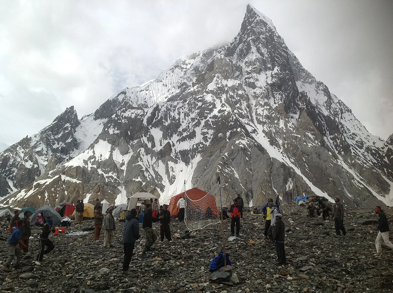
Concordia is the wide glacial junction at the heart of the Karakoram — around 4,600 m (sources vary up to roughly 4,700 m) — where the Baltoro and Godwin-Austen glaciers meet, and where four of the world’s fourteen 8,000-metre peaks stand within a single horizon: K2 (8,611 m), Gasherbrum I (8,080 m), Broad Peak (8,051 m) and Gasherbrum II (8,035 m). The American photographer Galen Rowell called it the “Throne Room of the Mountain Gods,” and the name has stuck for fifty years. There is no other patch of ground on earth quite like it. This is a guide from a team that walks these valleys — what Concordia is, how you get there, when to go, and the honest truth about the effort it asks.
Key Takeaways
- What it is: the confluence of the Baltoro and Godwin-Austen glaciers, ~4,600 m, ringed by four 8,000ers.
- Why it matters: the greatest concentration of high peaks on the planet — K2, Broad Peak, both Gasherbrums, plus Chogolisa, Mitre Peak and the Trango Towers on the approach.
- Getting there: Skardu to Askole by 4×4 (~7-9 hrs), then 6-9 days on foot up the Baltoro Glacier.
- Season: roughly April-October; the reliable window is June-September.
- Difficulty: no technical climbing to reach Concordia, but long, cold, remote, high-altitude glacier walking. Fitness and acclimatisation are non-negotiable.
What and where is Concordia?
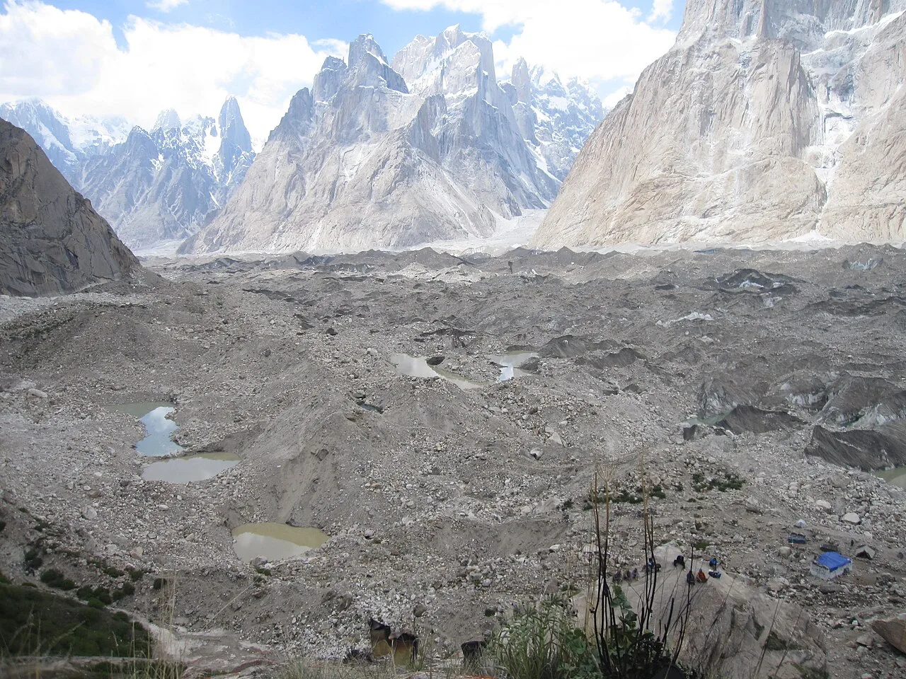
Concordia sits in Baltistan, deep in Pakistan’s Gilgit-Baltistan region, at roughly 4,600 m above sea level. It is not a summit or a village — it is a broad, rubble-strewn plateau of ice where two of the great glaciers of the Karakoram run together. The Baltoro Glacier, about 62-63 km long and one of the longest glaciers outside the polar regions, flows down from the east; the Godwin-Austen Glacier comes in from the north, straight off the foot of K2. A third ice stream, the Vigne Glacier, joins from the Chogolisa side just before the junction. Stand in the middle of it and the ice stretches away in three directions, walled by rock and snow on every side.
The name is older than it sounds. The British explorer William Martin Conway mapped this ground in 1892 and named it Concordia after Konkordiaplatz on the Aletsch Glacier in the Swiss Alps, another place where several streams of ice converge. The Karakoram version is simply on a far greater scale.
Why “the Throne Room of the Mountain Gods”?
That phrase comes from Galen Rowell, the American climber and photographer, whose 1977 book In the Throne Room of the Mountain Gods told the story of the troubled 1975 American expedition to K2. The book became a classic of mountaineering literature, and the title became the name everyone uses for Concordia.
It earns it. From one spot you look north up the Godwin-Austen Glacier to the bare pyramid of K2; swing your eye round and Broad Peak, the Gasherbrums, Chogolisa and the slender spire of Mitre Peak come one after another. Few of the trekkers who reach it talk about the walking afterwards. They talk about the silence, broken only by the crack of distant avalanches, and the feeling of being very small in a very large room.
The peaks you can see from Concordia
No other place on earth puts this many giants in one panorama. Four of the world’s fourteen 8,000-metre peaks cluster around the upper Baltoro, and a crowd of lower but no less famous summits fill in the gaps. Heights below are the widely cited figures; where sources differ we mark them approximate.
| Peak | Height | What it is |
|---|---|---|
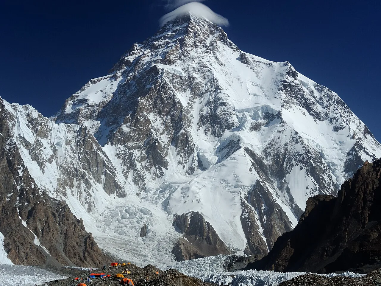
| K2 (Chogori) | 8,611 m | 2nd-highest mountain on earth; the savage mountain at the head of the Godwin-Austen. |
| Gasherbrum I | 8,080 m | Highest of the Gasherbrum massif; hidden behind the western faces. |
| Broad Peak | 8,051 m | The broad wall east of K2; often the Karakoram’s most achievable 8000er. |
| Gasherbrum II | 8,035 m | The most-climbed of the local 8000ers. |
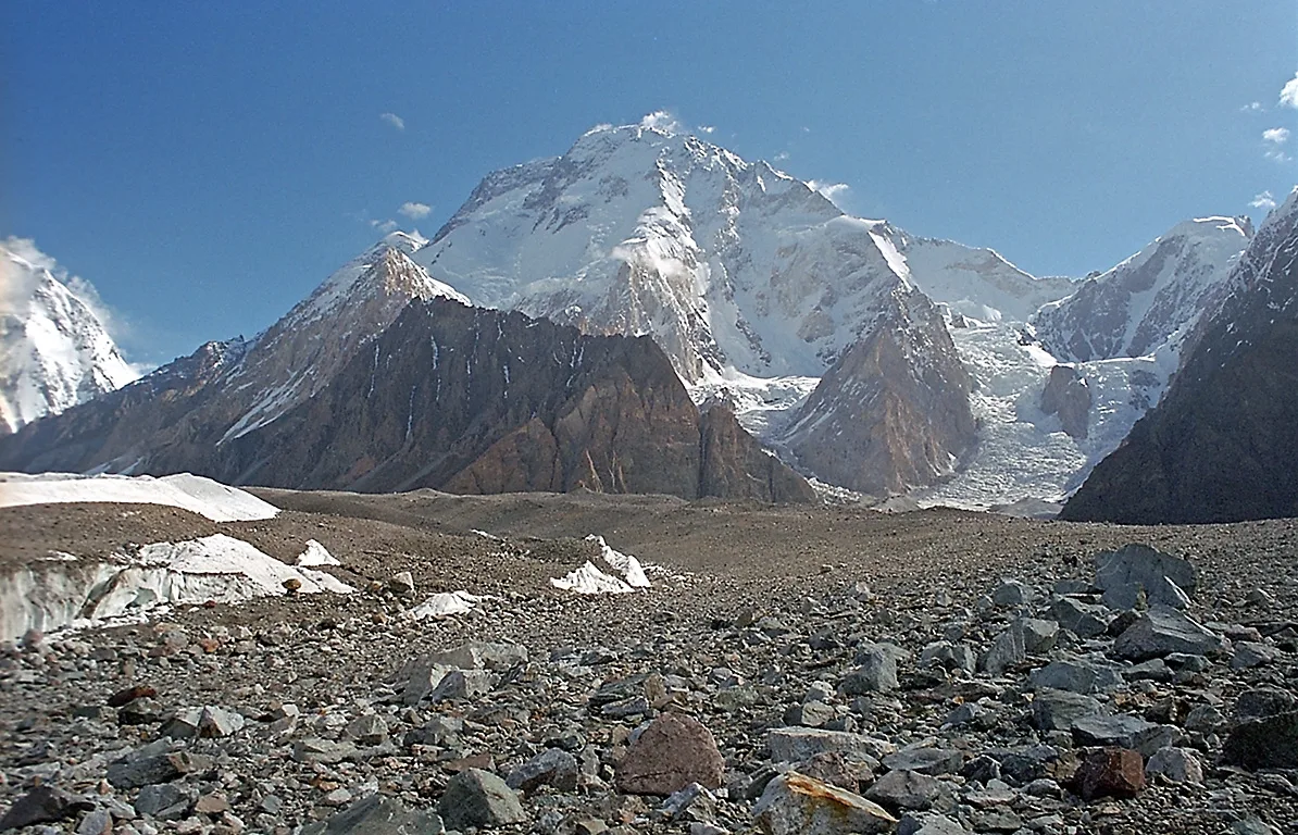
| Gasherbrum IV | ~7,932 m | The shining wall that glows at sunset above the glacier. |
| Chogolisa | ~7,665 m | The graceful snow ridge south of the junction. |
| Mitre Peak | ~6,010 m (approx.) | The unmistakable rock fin standing alone above Concordia. |
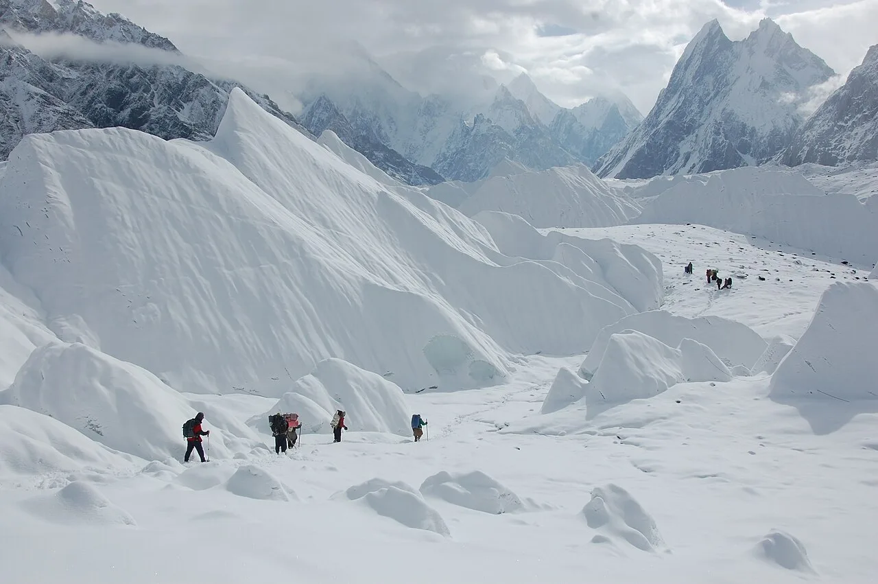
Getting there: the route up the Baltoro
There is only one way in, and it is on foot. The road ends at Askole, the last village, reached from Skardu by a rough 4×4 jeep ride of roughly seven to nine hours. From Askole you walk up the Braldu valley and then onto the Baltoro Glacier itself, camping at established sites as the ice climbs steadily toward Concordia. Most teams take six to nine walking days to reach it, depending on stages and acclimatisation; the same ground out again, unless you exit over a high pass (more on that below).
| Stage | Approx. altitude | Notes |
|---|---|---|
| Skardu → Askole | ~3,000 m | 4×4 jeep, ~7-9 hrs; the road head. |
| Askole → Jhula | ~3,200 m | Braldu valley walking. |
| Jhula → Paiju | ~3,450 m | Below the snout of the Baltoro; rest/acclimatise day common here. |
| Paiju → Khoburtse | ~3,800 m | First days on the glacier; Trango Towers come into view. |
| Khoburtse → Urdukas | ~4,050 m | Grassy ledges above the ice; one of the finest camps on earth. |
| Urdukas → Goro II | ~4,300 m | Out on the open glacier; cold, exposed camp. |
| Goro II → Concordia | ~4,600 m | The amphitheatre opens; K2 fills the head of the valley. |
When to go
The Baltoro is a summer route. The season runs roughly April to October, but the reliable window for reaching Concordia is June through September, when the high camps are workable and the jeep track to Askole is open. This is also the heart of the climbing season on the Baltoro — June and July you will share the glacier with expeditions heading for K2 and the Gasherbrums, which is part of the atmosphere. July and August give the warmest, most settled weather; September brings clearer air and thinner crowds, with a sharper cold at night.
Permits & visa note. Treks into this zone require a Trekking & Mountaineering visa (distinct from a standard tourist visa) and may need permits or an NOC depending on the exact route and the year’s regulations. The rules change, so we confirm the current requirements for your specific itinerary before you book rather than guessing. Bring it up early — paperwork is the one part of a Karakoram trip you cannot rush at the trailhead.
How hard is it? An honest answer
Reaching Concordia involves no roped climbing, no technical ground — but do not mistake that for easy. You are walking six to nine days on a moving glacier, much of it over loose rubble and ice, at altitudes between 3,000 and 4,600 m, carrying nothing heavier than a daypack but feeling every metre of the height. Nights are genuinely cold even in midsummer. The weather can shut the valley down for a day or two at a time. Help is days away on foot.
The risk, stated plainly. The real dangers here are altitude and remoteness, not cliffs. Acute mountain sickness is a serious possibility above 3,500 m and must be respected with a sensible acclimatisation profile and the willingness to turn around. There is no road, no quick evacuation; a rescue means a helicopter in good weather, or a long carry out.
This is exactly why we run every expedition with a satellite phone in camp, established helicopter-rescue contacts for the Baltoro region, insurance guidance, and a real emergency plan — not a brochure promise. Budget operators cut these to drop the price. We don’t. Local hands, real safety, fair price.
If you are weighing it against the more famous Nepali trek, our comparison of K2 Base Camp versus Everest Base Camp lays out the differences in difficulty, crowds and cost. For what to carry, our K2 Base Camp packing list applies almost exactly to a Concordia trek.
Concordia, K2 Base Camp, or out over Gondogoro La?
Concordia is the hub, and most itineraries push a little beyond it. From the junction you can walk north up the Godwin-Austen Glacier to K2 Base Camp (~5,150 m) at the foot of the mountain itself, often with a visit to the Gilkey Memorial. Many trekkers then return the way they came. The bolder option is to leave the Baltoro entirely by crossing Gondogoro La (5,585 m), a genuine high pass that drops you into the Hushe valley and turns the trip into a loop — and gives you a sunrise view of four 8000ers from the top. That pass is a serious undertaking with fixed ropes and an alpine start; it is not for everyone, and weather can close it.
On the approach you also pass beneath the Trango Towers, among the largest rock walls on earth, and the same season opens up neighbouring objectives like Broad Peak for those going higher. For a wider view of how Concordia fits among the country’s classic routes, see our roundup of the best treks in Pakistan.
Frequently asked questions
How high is Concordia?
Around 4,600 m above sea level. Sources vary slightly, with some citing figures up to roughly 4,700 m, because it is a broad glacial plateau rather than a single fixed point.
How many 8,000-metre peaks can you see from Concordia?
Four of the world’s fourteen: K2 (8,611 m), Gasherbrum I (8,080 m), Broad Peak (8,051 m) and Gasherbrum II (8,035 m), along with many lower giants such as Gasherbrum IV, Chogolisa and Mitre Peak.
How many days does the trek to Concordia take?
From Askole it is usually six to nine walking days each way, depending on the stages and acclimatisation. Add the jeep day from Skardu, rest days, and buffer days for weather, and a full Concordia trip typically runs two weeks or more.
Do I need climbing experience?
No technical climbing is required to reach Concordia or K2 Base Camp — it is glacier walking. You do need good hill fitness, the ability to handle multi-day cold and altitude, and sensible acclimatisation. Crossing Gondogoro La on the way out is a separate, more serious step that uses fixed ropes.
Why is it called the Throne Room of the Mountain Gods?
The phrase is the title of Galen Rowell’s 1977 book about the 1975 American K2 expedition. It captured the feeling of standing ringed by the highest peaks of the Karakoram, and the name has been used for Concordia ever since.
Walk into the Throne Room with a local team
Thinking about Concordia for 2026? WhatsApp us on +92 312 9921574 or email info@karakoramventure.com — you’ll be talking to a local Balti team who guide the Baltoro every season, not a broker reselling your trip. We’ll talk through dates, fitness, permits and a safety plan that actually exists.
Sources & further reading: Wikipedia — Concordia (Karakoram), Baltoro Glacier, K2, Konkordiaplatz and Galen Rowell; Galen Rowell, In the Throne Room of the Mountain Gods (Sierra Club Books, 1977) via the Internet Archive; SummitPost Baltoro-Concordia-K2 Base Camp trail. Altitudes and stage distances are widely cited approximate figures and vary between sources; we mark them as approximate where they differ.
[…] people walk to Concordia and turn around the way they came. The Gondogoro La is the alternative ending. Instead of retracing […]
[…] Pakistan, the mountain is reached up the Baltoro Glacier to Concordia, then up the Godwin-Austen Glacier to Base Camp at roughly 5,150 m. That approach alone — the […]