Gasherbrum IV (7,925 m / 26,001 ft) is the great fin of marble and ice that anchors the western end of the Gasherbrum group above Concordia — the 17th-highest mountain on earth and the highest independent peak under 8,000 m in Pakistan. Its huge West Face, the famous “Shining Wall,” catches the setting sun above the Baltoro Glacier and is among the hardest big-wall climbs in the Karakoram. First climbed in 1958 by Walter Bonatti and Carlo Mauri, it remains a peak for elite alpinists only. For almost everyone else — including us — Gasherbrum IV is a mountain you trek to see, not one you summit: the Gasherbrum Base Camp walk in via Askole and Concordia, roughly 14–16 days on the trail in the June–September season. We’re a Balti outfit based in Skardu, and this is our glacier.
Key Takeaways
- Height: 7,925 m (26,001 ft) — the 17th-highest mountain on earth, 6th-highest in Pakistan, and the highest independent summit below 8,000 m in the country.
- Where: the Gasherbrum massif of the Baltoro Muztagh, Karakoram, in Gilgit-Baltistan, Pakistan — its West Face looms straight over the Concordia glacial junction.
- Name: often called the “Shining Wall” for the way its West Face reflects the sunset, but “Gasherbrum” actually comes from the Balti rgasha brum, “beautiful mountain.” It was originally surveyed as K3.
- First ascent: 6 August 1958 by Walter Bonatti and Carlo Mauri, on an Italian expedition led by Riccardo Cassin, via the Northeast Ridge.
- What we run: the trek to Gasherbrum Base Camp (~5,150 m) to stand beneath the Shining Wall — and full base-camp logistics for experienced alpine teams attempting the climb.
- Honest read: the summit is one of the hardest in the world and not a guided commercial objective. We will never sell you a “guided” ascent of Gasherbrum IV — nobody credibly can.
Where Gasherbrum IV is, and why it haunts climbers
Walk up the Baltoro to Concordia, the great junction where the Baltoro and Godwin-Austen glaciers meet, and the skyline is a wall of giants — K2 to the north, Broad Peak to the east, and the Gasherbrum group closing off the south-east. The westernmost of that group, the steep trapezoidal fin that seems to glow at last light, is Gasherbrum IV. Its West Face rises some 2,500 m straight off the glacier, and on the trek in it is one of the most striking shapes in the whole Karakoram.
The peak was originally surveyed as K3, before the Balti name took hold. “Gasherbrum” is popularly translated as “Shining Wall,” a phrase that fits the West Face perfectly — but the honest etymology is the Balti rgasha brum, “beautiful mountain.” Both readings are true to what you see. At 7,925 m it is the 17th-highest mountain on earth and the sixth-highest in Pakistan, yet it stands lower than the four 8,000ers crowded around it. That is exactly why it is special: it is the highest independent peak under 8,000 m in the country, with its own clean prominence of 718 m, and a summit far harder to reach than its taller neighbours.
For the geography of the glacier highway it presides over, see our guide to the Baltoro Glacier, and our overview of the Gasherbrum I & II expeditions on the far side of the same massif.
Gasherbrum IV among the Baltoro giants
Set Gasherbrum IV next to the peaks that surround it and you see the trick the mountain plays: it is the shortest of this group by altitude, yet by difficulty it stands with the very hardest. Treat these heights as fixed reference figures from standard sources.
The trek to see the Shining Wall, step by step
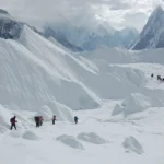
There is no road to Gasherbrum IV. To stand beneath the Shining Wall you walk the same magnificent glacier highway as the K2 Base Camp trek, then continue past Concordia toward the Gasherbrum base camps. The figures below are approximate and shift year to year with conditions on the ice.
- Skardu to Askole (1 day): a 4×4 jeep on rough mountain road, roughly 7–9 hours, to the last village (~3,020 m) and the trailhead.
- Askole to Paiyu (2 days): on foot along the lower Braldu and onto the snout of the Baltoro, camping at Jhola and then Paiyu (~3,450 m) below the Trango group.
- Paiyu to Urdukas (1–2 days): step onto the glacier proper, past the spires of the Trango Towers, to the grassy ledges of Urdukas (~3,950 m) — a rest and acclimatisation point.
- Urdukas to Concordia (2 days): a long haul up the medial moraine through Goro (~4,300 m) to Concordia (~4,600 m), where K2, Broad Peak and the Gasherbrums all come into view at once.
- Concordia to Gasherbrum Base Camp (~5,150 m): a further stage up the South Gasherbrum Glacier to the base camp area beneath the wall — the closest most trekkers will ever stand to Gasherbrum IV.
- The return: the same route reversed, or — for fit, well-acclimatised teams — an exit over the Gondogoro La to Hushe for a different valley out.
A wall with a fierce history
Gasherbrum IV’s climbing record is short, brilliant and bloody. The first ascent came on 6 August 1958, when the Italians Walter Bonatti and Carlo Mauri reached the top via the Northeast Ridge, on an expedition led by Riccardo Cassin. It was a tour de force on a peak nobody was sure could be climbed — and, tellingly, that 1958 line has never been repeated, shut down ever since by falling ice and rock.
The mountain’s legend, though, was sealed in 1985, when Poland’s Wojciech Kurtyka and Austria’s Robert Schauer made the first ascent of the 2,500 m West Face — the Shining Wall itself — in pure alpine style. Pinned by bad weather high on the wall, out of food and water, they reached the North Summit and survived a desperate descent down the Northwest Ridge without ever standing on the main top. It is still regarded by many climbers as one of the greatest Himalayan ascents ever made, precisely because they came back alive from a route that gives no margin.
The first ascent of that Northwest Ridge — now the “easiest” way up, a relative term here — followed in 1986, by Greg Child, Tim Macartney-Snape and Tom Hargis. In the decades since, the East and South faces and the south ridges have turned back every attempt, several of them fatally. Every Balti guide who works the Baltoro knows this history, and it is the reason we are blunt about what this peak is.
Safety, said plainly
Gasherbrum IV is, by any honest measure, one of the most dangerous mountains in the world to climb — serac fall, rock fall and a summit that has killed strong, experienced alpinists. We do not offer, and you should not trust anyone who offers, a “guided” client ascent of this peak. What we run is the trek to base camp and full expedition support for self-sufficient teams who already have the skill to attempt it. Even the trek to Gasherbrum Base Camp is a remote, glaciated, high-altitude undertaking: we carry a satellite phone in camp, hold established helicopter-rescue contacts for the Baltoro region, and plan crevasse safety and turn-arounds properly. Out here, the rescue plan has to be real before you start walking.
When to go
Gasherbrum IV sits on the standard Karakoram calendar. The Baltoro is only reasonably passable, and the high camps only survivable, in summer. Here is an honest month-by-month read for both the trek and any climb.
| Window | Conditions | Verdict |
|---|---|---|
| April – May | Deep snow, cold, the glacier approach still locked in; very few parties. | Too early for most |
| June – August | The main season; warmest, most settled spells, best summit windows and full base-camp services. | Best — go now |
| September | Shorter windows, colder nights, thinning crowds; fine for the trek, tight for a climb. | Late but workable |
| October – March | Winter on the Baltoro; brutal cold, the approach impractical. | Closed for normal trips |
Right now, in June, base camps along the Baltoro are filling for exactly this reason. For who else is on the glacier in season, see our overview of the Baltoro climbing season.
How hard is it, honestly — and what we actually offer
Let us be clear, because the brand is built on it: the summit of Gasherbrum IV is not a product anyone can sell you. It is a peak for a small handful of the world’s best alpinists, attempted in tiny self-sufficient teams, with a success rate that is brutally low and a fatality history that is not. If a company offers you a “guided” Gasherbrum IV with a summit promise, walk away.
What is genuinely open to fit, experienced trekkers is the walk to Gasherbrum Base Camp — the same demanding Baltoro approach as K2, ending beneath the Shining Wall. It is cold, remote and high (over 5,000 m), and you should arrive with real trekking fitness and ideally some glacier experience. For climbers who already have 7,000 m and 8,000 m peaks behind them and want to attempt the mountain, what we provide is the unglamorous half that keeps you alive: permits, liaison officer, porters, base-camp staff, food, fuel and a working rescue link. If you are building toward the big Baltoro objectives, the natural ladder runs through a first 7,000er like Chogolisa and an 8,000er like Broad Peak — not a leap straight onto this wall. Whatever your target, get the altitude right first; our acclimatisation guide covers how, without cutting corners.
Permits, getting there and cost
Permits & visa — read this early
Climbing Gasherbrum IV (well above 6,500 m) needs a mountaineering permit and royalty through Pakistan’s Alpine Club / Gilgit-Baltistan, a Trekking & Mountaineering visa (distinct from a tourist visa), and a registered liaison officer with the expedition. The base-camp trek through the Central Karakoram National Park requires a trekking permit and park fees rather than a climbing royalty, but still needs proper paperwork and lead time. We handle permits, the liaison officer and logistics end to end — just don’t arrive on a tourist visa expecting to go onto the glacier. Our Pakistan visa guide walks through it.
You reach the trailhead through Skardu. Most visitors fly Islamabad to Skardu when the weather allows, then take the long jeep ride to Askole; the overland road is a scenic but far longer alternative that needs buffer days. Our guide on how to get to Skardu covers both.
On cost, we keep pricing personal rather than posting a number that goes stale the moment permit fees or fuel change. What we promise is a fair price with no corners cut on guides, food or safety — tell us whether you want the base-camp trek or full expedition support, plus your dates and team size, and we’ll give you a straight quote. These are the valleys our team is from; you book the people who actually run the mountain.
Frequently asked questions
How high is Gasherbrum IV and where is it?
Gasherbrum IV is 7,925 m (26,001 ft), the 17th-highest mountain in the world and the highest independent peak under 8,000 m in Pakistan. It stands in the Gasherbrum massif of the Baltoro Muztagh, in Gilgit-Baltistan, with its West Face rising over the Concordia junction near K2 and Broad Peak.
Why is Gasherbrum IV called the Shining Wall?
The nickname refers to its huge West Face, which catches and reflects the light of the setting sun above the Baltoro. The name “Gasherbrum” itself comes from the Balti rgasha brum, meaning “beautiful mountain,” not literally “shining wall” — though both fit what you see.
Can I climb Gasherbrum IV with a guided commercial expedition?
No. Gasherbrum IV is one of the hardest and most dangerous peaks on earth, climbed only by elite alpinists in small self-sufficient teams, and it is not a guided commercial objective. We provide base-camp logistics and permits for qualified independent teams — and the trek to base camp for everyone who wants to see it.
Who first climbed Gasherbrum IV?
Walter Bonatti and Carlo Mauri made the first ascent on 6 August 1958, via the Northeast Ridge, on an Italian expedition led by Riccardo Cassin. The famous West Face, the Shining Wall, was first climbed in 1985 by Wojciech Kurtyka and Robert Schauer, who reached the North Summit.
When is the best time to trek to Gasherbrum Base Camp?
June to September is the season, with June to August the most settled. The Baltoro approach is snowbound and impractical from October through May, so trips run only in the short Karakoram summer.
Want to stand beneath the Shining Wall in 2026?
Planning the Gasherbrum Base Camp trek, or base-camp support for a climb? WhatsApp us on +92 312 9921574 or email info@karakoramventure.com — you’ll be talking to a local Balti team who guide these valleys ourselves, not a broker. Tell us your plans, fitness and dates, and we’ll give you an honest read — plus current permit fees and fixed departures.
Sources & further reading: Gasherbrum IV height, prominence, naming, first ascent (Bonatti and Mauri, 1958) and West Face history (Kurtyka and Schauer, 1985; Northwest Ridge, 1986) — Wikipedia and the American Alpine Journal. Geography of the Baltoro Glacier and Concordia, and trek stages via Askole — Wikipedia and standard trekking references. Altitudes are from these references; camp altitudes, trek durations and trip lengths are approximate and vary by season and operator.