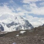
Chogolisa (7,665 m / 25,148 ft) is a twin-summited Karakoram giant that rises straight out of Concordia, a short walk beyond K2 Base Camp — the 36th-highest mountain on earth and one of the most beautiful, dangerous shapes in Gilgit-Baltistan. Its higher southwest summit was first climbed by an Austrian team in 1975; the northeast summit, the “Bride Peak,” fell to a Japanese expedition in 1958. This is a committed 7,000-metre expedition, not a trek — plan on roughly 30–40 days with a summit window in June to August, real fixed-rope and crevasse skills, and a healthy respect for the corniced ridges that killed Hermann Buhl here in 1957. We’re a Balti outfit based in Skardu, and these are the glaciers we work on.
Key Takeaways
- Height: 7,665 m (25,148 ft) at Chogolisa I (SW); the NE summit, “Bride Peak,” is 7,654 m. The 36th-highest peak in the world.
- Where: at the head of the Baltoro Glacier beside Concordia, in the Gilgit-Baltistan region of Pakistan — in plain sight of K2, Broad Peak and the Gasherbrums.
- Name: from the Balti Chogo Ling Sa, often rendered “Great Hunt”; Martin Conway named the NE summit “Bride Peak” in 1892.
- First ascents: NE summit by a Japanese team on 4 August 1958; the main SW summit by an Austrian team on 2 August 1975.
- Trip length: roughly 30–40 days door to door, including the multi-day trek in via Askole, the Baltoro and Concordia.
- Honest read: a serious, corniced, avalanche-aware climb for experienced mountaineers — beautiful, and unforgiving of mistakes on the descent.
Where Chogolisa is, and why climbers fall for it
Stand at Concordia, the great glacial junction where the Baltoro and Godwin-Austen glaciers meet, and turn your back on K2 for a moment. To the south-east sits a clean, trapezoidal wall of snow and ice: that is Chogolisa. It closes off the head of the Vigne Glacier and forms part of the skyline you cross on the Gondogoro La route to Hushe. Trekkers see it for days; climbers rarely forget it.
The name comes from the Balti Chogo Ling Sa — commonly translated “Great Hunt.” In 1892 the British explorer Martin Conway, surveying the Baltoro, looked at the elegant north-east summit and called it “Bride Peak,” a name that stuck for that side of the mountain. So Chogolisa carries two identities: the 7,665 m main summit on the south-west, and the 7,654 m Bride Peak on the north-east, separated by a long connecting ridge. That ridge, draped in cornices, is the heart of both the mountain’s beauty and its danger.
It is the 36th-highest mountain in the world and an ultra-prominent peak, rising 1,624 m above its connecting saddle. For the full geography of the glacier highway it sits at the head of, see our guide to the Baltoro Glacier.
Chogolisa among the Baltoro giants
Chogolisa is “only” a 7,000er in a neighbourhood of 8,000ers, which is exactly why it is sometimes overlooked — and exactly why it makes a serious objective for climbers building toward the bigger peaks. Here is how its height sits against its famous neighbours around Concordia. Treat these altitudes as fixed reference figures from standard sources.
The route, step by step
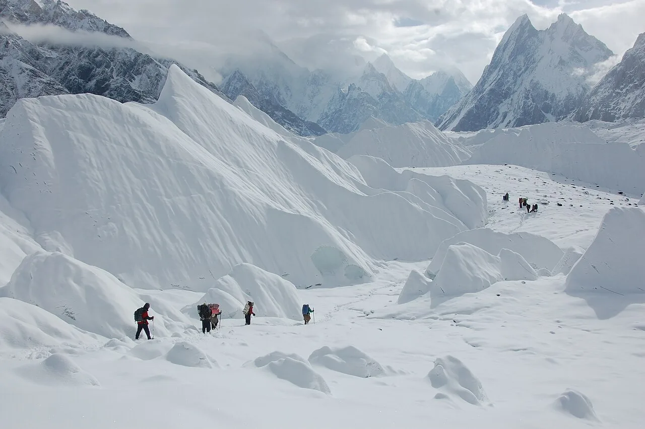
There is no road to Chogolisa. The expedition opens with one of the finest glacier walks on earth — the same approach as the K2 Base Camp trek — before the climbing even begins. Most teams attempt the south-west ridge / south-east ridge lines from the Vigne Glacier side, the broad approach the early expeditions used toward the Chogolisa saddle. The figures below are approximate and shift year to year with conditions.
- Skardu to Askole (1 day): a 4×4 jeep on rough mountain road, roughly 7–9 hours, to the last village and the trailhead.
- Askole to Concordia (5–7 days): on foot up the Baltoro Glacier through Jhula, Paiju, Urdukas and Goro, gaining altitude slowly — this walk is itself the first stage of acclimatisation.
- Concordia to Base Camp (~4,800 m): a short stage onto the Vigne Glacier below the mountain, where the team rests, organises loads and takes acclimatisation walks.
- The Chogolisa saddle (~6,300 m): the route gains a broad high saddle, the same ground the Duke of the Abruzzi reached in 1909 when he set a world altitude record here. High camps are placed on the way up the ridge.
- Summit ridge to 7,665 m: a long, corniced crest leads to the main south-west summit. This is the crux — not for technical steepness alone, but for the exposure and the route-finding among overhanging snow.
- The descent: every metre of that ridge is reversed on tired legs. On Chogolisa, the way down is the dangerous half of the day.
A mountain with a heavy history
Chogolisa’s record reads like a short history of Karakoram mountaineering. In 1909 the Duke of the Abruzzi reached about 7,498 m on the saddle before bad weather stopped him — a world altitude record that stood for thirteen years, until the British reached higher on Everest in 1922.
The mountain’s darkest chapter came in 1957. Fresh from the first ascent of nearby Broad Peak, the great Austrian climbers Hermann Buhl and Kurt Diemberger attempted Chogolisa alpine-style. On 27 June, less than 300 metres below the summit, a sudden snowstorm forced them back. On the descent Buhl — already legendary for his solo first ascent of Nanga Parbat — stepped onto a cornice that broke beneath him, and fell down the near-vertical north face. His body has never been found. Every guide who works this glacier knows that story, and it shapes how we move on corniced ground.
The first ascent of the north-east summit, the Bride Peak, came on 4 August 1958 via a Japanese expedition from Kyoto University. The higher south-west summit waited until 2 August 1975, when an Austrian team led by Eduard Koblmüller put Fred Pressl and Gustav Ammerer on top — and Koblmüller himself nearly repeated Buhl’s fate, breaking through a cornice but held by the rope and his team. The lesson of Chogolisa, written twice in the same place: on this mountain, the rope and good judgement are everything.
Safety, said plainly
Chogolisa’s defining hazard is its cornices — overhanging shelves of wind-packed snow on the summit ridges that can break far back from the apparent edge. That is what killed Hermann Buhl here, and what nearly killed the man who made the first ascent. Add avalanche risk on the approach slopes and the usual altitude danger above 6,000 m. We run every expedition with a satellite phone in camp, established helicopter-rescue contacts for the Baltoro region, fixed rope on the exposed sections and a turn-around time we hold to. On Chogolisa, getting down alive is the whole job — the summit is only halfway.
When to go
Chogolisa follows the standard Karakoram expedition calendar. The glaciers are only reasonably stable, and the high camps only survivable, in summer. Here is an honest month-by-month read.
| Window | Conditions | Verdict |
|---|---|---|
| April – May | Deep snow, cold, glacier approach still locked in; few teams. | Too early for most |
| June – August | The main climbing season; warmest, most settled spells and the best summit windows. | Best — go now |
| September | Shorter weather windows, colder nights, thinning crowds; possible for fast teams. | Late but workable |
| October – March | Winter conditions; the Baltoro is brutal and the approach impractical. | Closed for normal trips |
Right now, in June, base camps along the Baltoro are filling for exactly this reason. For who else is on the glacier in season, see our overview of the Baltoro climbing season.
How hard is it, honestly
Chogolisa is a real expedition peak, not a trekking peak with a summit bolted on. The altitude alone — over 7,600 m — puts it firmly in the territory where supplementary acclimatisation, careful rotations and patience matter. The technical climbing is moderate by Karakoram standards, mostly snow and ice on the ridge, but the exposure and corniced ground demand confident cramponing, crevasse-rescue competence and the judgement to read unstable snow. You should arrive with prior glacier and high-altitude experience — ideally a 6,000 m peak already climbed.
If you are building toward the bigger Baltoro objectives, Chogolisa is an excellent step between a first 6,000er and the 8,000ers. Many climbers pair it in their planning with our Spantik (Golden Peak) expedition as a 7,000 m apprenticeship before Broad Peak or the Gasherbrums. Whatever your target, get your acclimatisation right — our acclimatisation guide covers how to do it without cutting corners.
Permits, getting there and cost
Permits & visa — read this early
Chogolisa is above 6,500 m, so it requires a mountaineering permit and royalty through Pakistan’s Alpine Club / Gilgit-Baltistan, a Trekking & Mountaineering visa (distinct from a tourist visa), and a registered liaison officer with the expedition. These need real lead time. We handle the permit process, liaison officer and logistics end to end — but apply early, and don’t arrive on a tourist visa expecting to climb. Our Pakistan visa guide walks through the paperwork.
You reach the trailhead through Skardu. Most climbers fly Islamabad to Skardu when the weather allows, then take the long jeep ride to Askole; the overland road is a scenic but much longer alternative needing buffer days. Our guide on how to get to Skardu covers both.
On cost, we keep pricing personal rather than posting a number that goes stale the moment permit fees or fuel change. What we promise is a fair price with no corners cut on guides, food or safety — tell us your dates and team size and we’ll give you a straight quote. The Hushe and Concordia valleys are where our team is from; you book the people who actually run the mountain.
Frequently asked questions
How high is Chogolisa and where is it?
Chogolisa’s main south-west summit is 7,665 m (25,148 ft), the 36th-highest mountain in the world; its north-east summit, the “Bride Peak,” is 7,654 m. It stands at the head of the Baltoro Glacier beside Concordia, in Gilgit-Baltistan, Pakistan, near K2 and Broad Peak.
Why is Chogolisa called the Bride Peak?
The explorer Martin Conway named the elegant north-east summit “Bride Peak” in 1892 during his Baltoro survey. The mountain’s local name comes from the Balti Chogo Ling Sa, usually translated “Great Hunt.”
How difficult is Chogolisa to climb?
It is a serious expedition peak. The climbing is moderate by Karakoram standards — mostly snow and ice — but the altitude above 7,600 m, the exposure and the heavily corniced summit ridges make it dangerous and demanding. Prior glacier and high-altitude experience, ideally a 6,000 m peak, is expected.
When is the best time to climb Chogolisa?
June to August is the main season, when the weather settles enough to give safe summit windows. April–May is usually too snowbound and the approach impractical; the winter months are closed for normal expeditions.
What permits do I need for Chogolisa?
A mountaineering permit with royalty, a Trekking & Mountaineering visa (not a tourist visa), and a registered liaison officer. We arrange the permit, liaison officer and full logistics, but the paperwork needs lead time, so start early.
Thinking about Chogolisa in 2026?
Planning your climb? WhatsApp us on +92 312 9921574 or email info@karakoramventure.com — you’ll be talking to a local Balti team who guide these valleys ourselves, not a broker. Tell us your climbing history and dates, and we’ll give you an honest read on whether Chogolisa is your mountain — plus current permit fees and fixed departures.
Sources & further reading: Chogolisa height, prominence, naming and climbing history (Duke of the Abruzzi 1909; Buhl and Diemberger 1957; first ascents 1958 and 1975) — Wikipedia and the American Alpine Journal / Himalayan Journal. Geography of the Baltoro Glacier and Concordia — Wikipedia. Altitudes are from these references; camp altitudes, trek durations and trip lengths are approximate and vary by season and operator.