



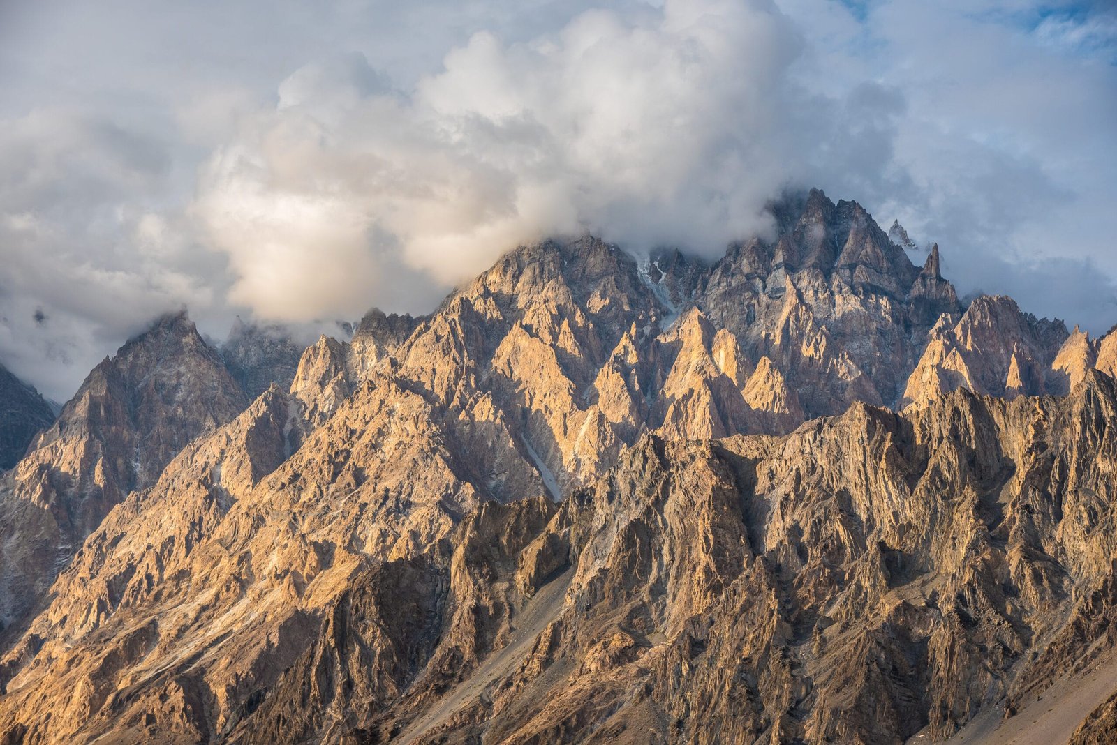
The Passu Cones — Tupopdan, 6,106 m (20,033 ft) — are the row of saw-toothed rock spires that rise straight off the Karakoram Highway in Upper Hunza. They stand about 10 km north of Passu village in Gilgit-Baltistan, Pakistan. You don’t trek to see them. They stand over the road, and the best of them you can photograph in an afternoon. Behind them runs the Batura Glacier, 57 km long and one of the longest glaciers outside the polar regions. You reach it on a 7–10 day trek from Passu, through Wakhi summer pastures. The viewpoints are open all year; the high pastures and glacier trek run roughly June–September. It is moderate-to-hard walking at altitude, not a technical climb.
We run this out of Skardu with our own Balti team, and we’ll be straight with you. Passu is in Hunza, not Baltistan. So it is one of the few headline sights of the north you can reach on a normal road trip up the Karakoram Highway. No jeep epic, and no glacier crossing required just to look. The Cones reward five minutes; the Batura behind them asks for a week and real legs. This guide covers both honestly.
Passu Cones: key takeaways
- Passu Cones (Tupopdan): 6,106 m (20,033 ft). It is a rock ridge in the South Ghujerab Mountains of the Batura Muztagh, about 10 km north of Passu village.
- Where: Gojal (Upper Hunza), Hunza District, Gilgit-Baltistan — right on the Karakoram Highway, roughly 132 km northeast of Gilgit.
- Batura Glacier: about 57 km long, among the longest glaciers outside the polar regions. It flows down the Batura Muztagh, whose high peaks include Batura Sar (7,795 m) and Passu Sar (7,478 m).
- Effort: seeing the Cones is roadside and easy. The Batura Glacier trek to the summer pastures is a moderate-to-hard walk of roughly 7–10 days, with camps around 3,300–3,400 m.
- When: the Cones are visible year-round (autumn is glorious); the glacier trek and pastures run roughly June–September.
- First ascent of Tupopdan: 6 July 1987, by the British climbers Andy Cave and John Stevenson, via the Northeast Ridge. The summit itself is a serious technical objective; almost everyone comes to look, not climb.
Where the Passu Cones are, and why they stop the traffic
Drive north up the Karakoram Highway through Hunza and, somewhere past Gulmit, the valley wall in front of you breaks into a wall of dark, near-vertical spires. That is Tupopdan — a name often translated as “the shining wall” — better known to travellers as the Passu Cones or the Passu Cathedral. The ridge tops out at 6,106 m. Its north side rises about 1,700 m in just 1.5 km. That is why the rock looks so impossibly steep from the road. There is no walk-in: the most famous mountains in northern Pakistan are, for once, ones you meet at a roadside tea stall.
Passu village sits in Gojal, the upper part of the Hunza valley, roughly 132 km northeast of Gilgit. Because it is on the highway, it pairs naturally with the rest of a Hunza trip. That means Karimabad, Attabad Lake, the Hussaini suspension bridge a few kilometres south, and Borith Lake up a side track. If you are building a wider northern itinerary, our Skardu travel guide and the Hunza cherry blossom guide cover the seasons and the surrounding valleys.
Tupopdan among the Hunza giants
The Cones are spectacular, but by Karakoram numbers they are modest. It is their shape and the way they leap off the road, not their height, that makes them famous. Set Tupopdan against the true giants of the Batura Muztagh that stand behind and around Passu and the scale becomes clear. Treat these as fixed reference heights from standard sources.
The Batura Glacier trek, step by step
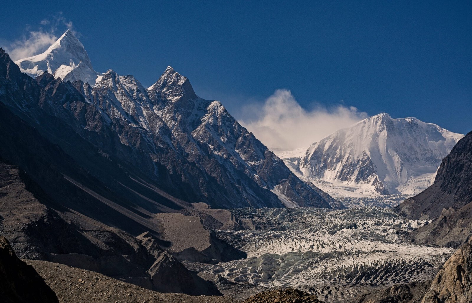
Behind the Cones lies the real expedition country. The Batura Glacier is a river of ice about 57 km long, one of the longest outside the polar regions. It drains the Batura Muztagh from west to east. You don’t see it from the highway. You walk to it from Passu, climbing through the Wakhi summer pastures. There, families bring yaks, sheep and cattle up for the short green months. The figures below are approximate and shift year to year with the ice and the weather.
- Passu trailhead (day 1): leave the village (~2,500 m) and climb above the glacier’s snout. The line often runs via the settlement of Yunzbin, onto the lateral moraine.
- Onto the ice and across to Yashpirt: pick a line across or alongside the rubble-covered glacier to the summer pasture of Yashpirt (~3,300–3,400 m). That is the classic first camp, several hours of broken walking.
Onto the upper pastures
- The upper pastures (1–2 days): continue up the true left of the glacier to higher meadows and shepherd settlements. Above you the Batura wall and Passu Sar open up.
- Glacier viewpoints (~3,800–4,000 m): push to a high vantage over the great ice stream and its tributaries — the turnaround for most trekkers.
- The return: the same pastures reversed to Passu, usually faster. The round trip runs roughly 7–10 days, depending on how high and how slow you go.
The view, the ice and the Wakhi pastures
Two great glaciers pour off the mountains at Passu. One is the long Batura behind the Cones. The other is the steeper, more crevassed Passu Glacier right beside the village, which tumbles almost to the road. Many travellers walk an hour or two onto the lower Passu Glacier, or up to Borith Lake for the classic view. The full Batura trek to the pastures is the bigger commitment. Up there, the reward is not a single summit photo but a working alpine world. There are stone shepherd huts, grazing yaks and meltwater channels, and the Wakhi families whose summer life still runs on this ice.
This is gentler altitude than the Baltoro giants, but it is real mountain ground. If you want to go higher in this same corner of the Karakoram afterwards, the Rakaposhi Base Camp trek and the Rush Lake trek in neighbouring Nagar are the natural next steps, and our roundup of the best treks in Pakistan puts them in order.
Safety, said plainly
The Cones from the road are safe enough for anyone. The Batura Glacier is not a place to wander alone. It is a living, moving glacier with hidden crevasses, unstable moraine and meltwater that rises through the day; people have been hurt and lost on it. We walk it with a local Balti or Wakhi guide who knows the current line across the ice. We also carry a satellite phone on the multi-day trek, and hold established helicopter-rescue contacts for the region. The weather turns fast, and there is no road at the pastures. So the rescue plan has to be real before you step onto the ice, not improvised after.
When to go
Passu rewards two very different visits. One is a quick highway stop for the Cones, which works most of the year. The other is the glacier trek, which has a short summer window like the rest of the high Karakoram. Here is an honest month-by-month read.
| Window | Conditions | Verdict |
|---|---|---|
| April – May | Spring on the highway; blossom in Hunza, Cones clear on good days, but the pastures still under snow. | Great for the Cones, early for the trek |
| June – August | Warmest, most settled; pastures green, shepherds up, the glacier trek fully in season. | Best — trek season |
| September | Crisp, clear, thinning crowds; pastures emptying but still walkable, superb light on the Cones. | Excellent, especially late |
| October – March | Cold; autumn colour early, then winter. Cones can be stunning under snow, but the trek is closed. | Roadside only |
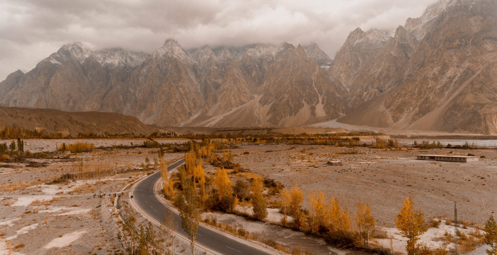
Autumn, from mid-September, is many photographers’ favourite time here — golden poplars below black spires. To time the wider region and get your altitude right before the trek, read our acclimatisation guide.
How hard is it, honestly
Be clear about which Passu you are coming for. Seeing the Cones is effortless — a roadside stop, a short stroll to a viewpoint, photographs and tea. Walking an hour onto the lower Passu Glacier or up to Borith Lake is easy day-hiking for anyone reasonably fit. The full Batura Glacier trek is a different animal: moderate-to-hard, with loose moraine, glacier travel, long days and camps above 3,300 m. You don’t need technical climbing skill, but you do need genuine hill fitness, decent boots and a guide who reads the ice. Come prepared — our Karakoram packing list covers exactly what the pastures and the glacier demand.
Permits, getting there and cost
Permits & visa — read this early
Good news for Passu: Hunza/Gojal is an open trekking zone. So the Cones and the Batura Glacier pasture trek do not need a mountaineering permit or royalty, unlike the restricted Baltoro peaks. You still need the right Pakistan visa, and any actual climbing of Tupopdan (well above 6,000 m) is a different, permitted matter. For trekkers the key point is the visa: come on the correct one, not just a short tourist stamp if you plan serious trekking. Our Pakistan visa guide walks through it, and we sort any local paperwork end to end.
Getting to Passu
Getting there is the easy part, by northern-Pakistan standards: Passu is on the Karakoram Highway, reached by road up through Hunza from Gilgit, with no jeep ordeal to the trailhead — you start walking from the village itself. Most travellers fly Islamabad to Gilgit or Skardu and drive up, or take the long overland route on the KKH. Our guide on how to get to Skardu covers the flight-versus-road trade-offs that apply to the whole north.
On cost, we keep pricing personal rather than posting a number that goes stale the moment fuel or permit fees change. What we promise is a fair price with no corners cut on guides, food or safety — tell us whether you want a Hunza road trip taking in the Cones, a few days on the Passu and Batura glaciers, or the full pasture trek, plus your dates and group size, and we’ll give you a straight quote. These are the valleys our team is from; you book the people who actually walk the ice.
You can stand under the Cones this season. Day four of our 7-day Hunza Valley Tour Package is a full Gojal day — Attabad by boat, Gulmit, the Hussaini bridge and the Passu Cones — from $860 per person with a KKH driver-guide, hotels and meals.
Borith in a day from Karimabad. Our Eagle’s Nest Sunrise & Borith Lake Day Tour starts with sunrise from Duikar over Rakaposhi, then runs north past Attabad to Borith Lake under the Passu glacier, from $65 per person.
Two treks from Passu. The Batura Glacier Trek is the long, lower one: eight days from Hunza through Yunzbin, Yashpirt and Guchesham, two roped glacier crossings, from $1,280 per person. The Patundas Meadows Trek is the short, higher one: six days across the Passu glacier to meadows at about 4,100 m facing Shispare, from $990.
Frequently asked questions
How high are the Passu Cones and where are they?
The Passu Cones, properly Tupopdan, top out at 6,106 m (20,033 ft). They stand in the Batura Muztagh of the Karakoram, about 10 km north of Passu village in Gojal (Upper Hunza), Gilgit-Baltistan, right beside the Karakoram Highway roughly 132 km northeast of Gilgit.
Do I need to trek to see the Passu Cones?
No. The Cones rise straight above the Karakoram Highway, so you can see and photograph them from the roadside and nearby viewpoints in Passu without any trek. The multi-day walking is for the Batura Glacier and its summer pastures behind them.
How long is the Batura Glacier trek and how hard is it?
The trek from Passu through the Wakhi pastures to the Batura Glacier viewpoints takes roughly 7–10 days and is moderate-to-hard: loose moraine, glacier travel and camps around 3,300–3,400 m, but no technical climbing. You need good hill fitness and a guide who knows the route across the ice.
When is the best time to visit Passu?
The Cones are visible most of the year and are stunning in autumn light from mid-September. The Batura Glacier trek and the high pastures run roughly June to September, with June to August the most settled. Winter closes the trek but can make the Cones spectacular under snow from the road.
How long is the Batura Glacier?
The Batura Glacier is about 57 km long, one of the longest glaciers outside the polar regions. It drains the Batura Muztagh, a sub-range of the Karakoram whose peaks include Batura Sar at 7,795 m and Passu Sar at 7,478 m.
Want the Cones and the Batura ice in 2027?
Planning a Hunza road trip past the Passu Cones, or the full Batura Glacier pasture trek? WhatsApp us on +92 312 9921574 or email info@karakoramventure.com — you’ll be talking to a local Balti team who guide these valleys ourselves, not a broker. Tell us your plans, fitness and dates, and we’ll give you an honest read, fair pricing and the right route.
Sources & attribution: Tupopdan height (6,106 m), location, north-face figures and first ascent (Andy Cave and John Stevenson, 6 July 1987); Batura Glacier length (~57 km) and the Batura Muztagh peaks (Batura Sar 7,795 m, Passu Sar 7,478 m); Passu village and Gojal geography, the Hussaini bridge and distances — Wikipedia and standard references. Trek durations, camp altitudes and seasons are approximate and vary year to year. Images: Obaid Ahmed (CC BY-SA 4.0), Muhammad Ashar (CC BY-SA 4.0) and Zubair Ahmad Nagra (CC BY-SA 4.0), all via Wikimedia Commons.

