



The Thalle La is a roughly 4,572 m (15,000 ft) pass in Baltistan. It links the Shigar Valley on the Skardu side with the Thalle and Khaplu valleys on the Shyok side. The Thalle La trek follows an old trade and shepherd route, walked in about five to seven days. There is no glacier crossing and no technical climbing. Consequently it is one of the gentlest high treks in the Karakoram. The season runs June to September, and from the top you look straight at the Masherbrum range.
We also run this trek out of Skardu with our own Balti team. We will be straight with you. The Thalle La is not a savage mountain ordeal like the high passes near Concordia. In fact that is exactly why it is worth your time. It is a real high crossing on a historic route. However it is forgiving enough to be a first Karakoram trek, or a proper acclimatisation walk before something bigger. Below is the honest, fully-researched guide. It covers altitude, route, season, difficulty, cost guidance and the safety realities. Every number is checked against published sources.
Key Takeaways
- Elevation: the Thalle La pass sits at roughly 4,572 m (15,000 ft); sources vary by a few metres.
- Where: Baltistan, Gilgit-Baltistan — the pass connects the Shigar Valley with the Thalle and Khaplu valleys on the Shyok River.
- Duration: about 5–7 days on the trail; most packages run 7–10 days including travel from Skardu.
- Difficulty: easy-to-moderate by Karakoram standards — no glacier crossing, no technical ground — but still high and remote.
- Season: June to September, when the meadows are in flower and the pass is clear of deep snow.
- The reward: alpine pastures, working summer villages, and a pass-top view of the Masherbrum range and Mango Gusor (6,288 m).
Where is the Thalle La, and why does it matter?
The Thalle La (also spelled Thalay La or Thale La) is a pass in the heart of Baltistan, hung between two of its great valleys. On the north-west side lies the broad, green Shigar Valley that runs up toward Askole and the Baltoro. On the south-east side is the Thalle Lungma. That long valley drops to the Shyok River, roughly 15 km west of Khaplu and about 85 km east of Skardu. For centuries this pass was the direct foot-and-pony link between the two. According to local and trekking histories, the British used the Skardu–Khaplu route between 1891 and 1947. Specifically, they wanted its grazing grounds, which fed their pack animals on the march.
That history matters because it tells you what kind of trek this is. Still, it is not an expedition approach hacked across moraine and ice. It is an old human road over the mountains: meadows, shepherd huts, summer settlements and a single high col. Indeed it is the sort of route Balti families and traders actually used. It belongs to the same Hushe-and-Khaplu corner of the range as our Masherbrum (K1) trek and the Charakusa Valley, but it asks far less of your body.
How high is it? The pass in context
At about 4,572 m, the Thalle La is a genuine high pass, higher than most people will have stood before. Still, it is modest next to the famous crossings of the Karakoram. That gap is the whole point. It gives you altitude and a real summit-of-the-walk moment, without the danger of a glaciated 5,500 m col. Here is how it sits among Karakoram trekking passes (elevations approximate; sources vary by a few metres):
Put beside the Laila Peak and Hushe objectives or the high glaciated passes, the Thalle La reads as the friendly one. We often suggest it to trekkers who want the Karakoram experience: the villages, the pastures, the scale. That comes before they commit to a base-camp route. It is also a sound acclimatisation leg; if that is your plan, read our acclimatisation guide first.
The route: Shigar to Khaplu, step by step
The Thalle La can be walked in either direction. Many teams start on the Shigar side and finish above Khaplu, or reverse it; the trailhead settlements are reached by jeep from Skardu. Olmo is the highest summer settlement on the Thalle side and a common start or end point. The villages of Thalle and Barah anchor the lower valley. Below is a typical west-to-east plan — your guide will adjust it to snow, weather and your pace.
A typical itinerary (5–7 days on the trail)
- Day 1 — Skardu to the roadhead. Drive by 4×4 into the Shigar or Thalle valley, then walk to a first camp among fields and summer houses (~3,000 m).
- Day 2 — Into the pastures. Follow the valley through shepherd settlements and flower meadows, gaining height gently toward the higher grazing grounds.
- Day 3 — High camp below the pass. A steadier climb to a camp at roughly 3,800–4,000 m, set up for an early start the next morning.
- Day 4 — Cross the Thalle La (4,572 m). A pre-dawn push to the col — often a couple of hours from high camp — for the Masherbrum view, then a long descent down the far valley.
- Days 5–7 — Down to the road. Drop through pastures and villages on the Khaplu side to the roadhead, with a buffer day for weather or rest, then jeep back.
It is short and uncomplicated on paper, and mostly it is. The walking is on grass, earth and rock rather than ice, and the days are manageable. What you should not underestimate is the altitude and the remoteness — once you are in the upper valley you are a long way from a road or a clinic. That is where having a local team matters.
Trek elevation profile
Safety reality: the Thalle La is gentle by Karakoram standards, but it is still a high, remote pass. Early or late in the season the col can hold snow and ice that turns an easy walk into a slip risk, and weather on top changes fast. The real danger here is altitude and being far from help, not technical climbing. We carry a satellite phone and a genuine evacuation plan on every trek, because the nearest road and clinic are a long way down. Local hands, real safety, fair price.
The view: Masherbrum and the giants behind
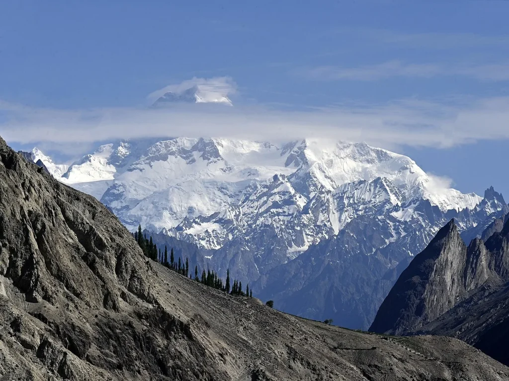
From the top of the Thalle La the eye goes straight to the Masherbrum range — the wall of peaks once labelled K1 — with the rock pyramid of Mango Gusor (about 6,288 m) standing out nearby. Behind that range, out of sight but close, lie the Hushe giants you may recognise from our other guides: K6 and K7 above the Charakusa, and the spire of Laila Peak. Here is the scale you are standing under (summit elevations approximate):
This is the quiet appeal of the Thalle La: you are not staring up at a single base-camp monster from the bottom of a glacier, you are walking a balcony route with the Masherbrum range laid out in front of you. For trekkers who later want the big stuff, it pairs naturally with the Hushe-side objectives — Laila Peak and the Charakusa Valley.
When to go: season & weather
The window is June to September. Before June the pass and upper meadows hold snow, and the crossing is colder and harder underfoot; by October the high camps shut down for winter. June brings the meadows into flower and the fewest crowds, while July and August are the warmest and most settled. September is crisp and quiet, with the first cold nights of autumn. This is the same broad summer season that opens the rest of the range, so plan flights and logistics early — see our notes on the best treks in Pakistan.
| Month | Conditions | Verdict |
|---|---|---|
| Apr–May | Snow on the pass, cold high camps, muddy lower valley | Too early |
| June | Meadows flowering, fewer people, some snow lingering high | Good |
| July–Aug | Warmest, most settled, summer villages fully alive | Best |
| September | Crisp, quiet, cold nights; weather beginning to turn | Good, late-season |
| Oct–Mar | Snowbound, pass and high camps closed | Closed |
How hard is it? Fitness, altitude & terrain
Honest answer: easy to moderate by Karakoram standards — which still means a fit, prepared body. The route involves no glacier travel and no technical climbing, and the daily distances are reasonable, mostly on grass, earth and rock. What makes it a real trek is the single big climb to the pass and the altitude: you sleep at around 3,800–4,000 m and cross at roughly 4,572 m, high enough that altitude sickness is a genuine risk if you rush the acclimatisation.
If you can walk uphill for five or six hours with a daypack and you respect the height, you can do the Thalle La. We still build in sensible acclimatisation and watch every client — if you are new to high trekking, read our acclimatisation guide before you commit. Pack for real mountain cold and strong sun at altitude; our Karakoram trek packing list covers exactly what to bring.
Permits & access note: the Thalle La is an open-zone trek and does not require the special mountaineering permit that 8,000 m peaks and restricted areas need. You do, however, need the correct Pakistan visa, and rules can change. Foreign trekkers should read our Pakistan visa guide and confirm any local registration with us before travel.
Getting there & what it costs
Everything starts in Skardu. You can fly in from Islamabad or come overland — our guide on how to get to Skardu lays out both options, and the wider Skardu travel guide covers where to stay and acclimatise before you walk. From Skardu it is a 4×4 drive into the Shigar or Thalle valley to reach the trailhead. Because the trek finishes on the Khaplu side, it also slots neatly into a wider Baltistan loop — many travellers tie it to Deosai National Park or the Hushe valleys.
Costs vary with group size, days and service level, so we keep pricing personal rather than posting a number that goes stale. What we will promise: a fair price with no corners cut on guides, food or safety gear. WhatsApp us for current 2027 dates and a quote.
Frequently asked questions
How high is the Thalle La pass?
The Thalle La sits at approximately 4,572 m (15,000 ft). Sources vary by a few metres, but the commonly cited figure is around 4,572 m.
How many days is the Thalle La trek?
Most parties spend about 5–7 days on the trail, with a buffer day for weather. Full packages typically run 7–10 days once you include the drive from Skardu and acclimatisation.
Is the Thalle La trek difficult?
It is easy to moderate by Karakoram standards — no glacier crossing and no technical climbing, but a real high pass at around 4,572 m. Good fitness and proper acclimatisation matter, and it makes a strong first Karakoram trek.
What is the best time to do the Thalle La trek?
June to September. July and August are the warmest and most settled; June brings flowering meadows and fewer people; September is crisp and quiet but colder, with weather starting to turn.
Do I need a permit for the Thalle La?
The Thalle La is in an open trekking zone and does not require the special mountaineering permit needed for 8,000 m peaks. You still need the correct Pakistan visa, and you should confirm any local registration with your operator before travel.
Plan your Thalle La trek
Want a real Karakoram crossing that won’t break you? WhatsApp us on +92 312 9921574 or email info@karakoramventure.com — you’ll be talking to a local Balti team, not a broker. We’ll sort dates, group size, acclimatisation and safety, and walk you over the old pass the right way.
Sources & attribution: pass elevation, geography and route history compiled from established Pakistan trekking references and operator route notes; peak elevations (Masherbrum, K6, K7, Mango Gusor) and comparison passes (Gondogoro La, Hispar La, Shimshal Pass) from published mountaineering references. Figures are approximate where sources differ.

