



Skardu’s best single day out doesn’t need a jeep permit, an expedition budget, or a mountaineering visa — it needs a car, about five to six hours, and a reasonable pair of shoes. This Skardu day tour takes you up the 16th-century ramparts of Kharpocho Fort, in front of an 8th-century Buddha carved into a granite cliff face at Manthal, and out to Satpara Lake, a glacial-fed reservoir sitting at roughly 2,600 m below the Deosai Plains. It runs nearly year-round, needs nothing beyond your standard Pakistan tourist visa, and works as an easy day for travelers who aren’t trekking at all — or a good warm-up before a bigger one.
We build this loop into a lot of our Skardu itineraries — expedition clients waiting on a weather delay, family groups wanting a cultural morning before Deosai, honeymooners breaking up the drive toward the heritage valleys. It is not a trek and we won’t sell it as one. But the three stops cover close to a thousand years of Baltistan’s history and the geology underneath it, and our Balti guides can walk you through both without turning it into a lecture. Local hands, real safety, fair price — that applies here too, even on a day that never touches a glacier.
Key takeaways
- Three stops, one loop: Kharpocho Fort (16th century), Manthal Buddha Rock (~8th century), and Satpara Lake (2,600 m) — all within about 10 km of central Skardu.
- Total time is roughly 5–6 hours including the fort climb, the drives between stops, and time at the lake; doable as a morning outing or a full day with lunch by the water.
- Season: essentially year-round. Spring through autumn (March–October) is easiest; winter (December–February) can bring snow and ice on the upper Satpara road.
- Difficulty: easy. The only real exertion is a steep 15–20 minute climb up an uneven stone stairway to the fort; everything else is a short drive and a walk.
- Permits: none beyond a standard Pakistan tourist visa. This is an open tourism zone, not a restricted trekking corridor.
- Pairs well with a Deosai jeep safari, the Shigar or Khaplu heritage circuits, or a rest day before or after a Baltoro trek.
Three stops, one river valley
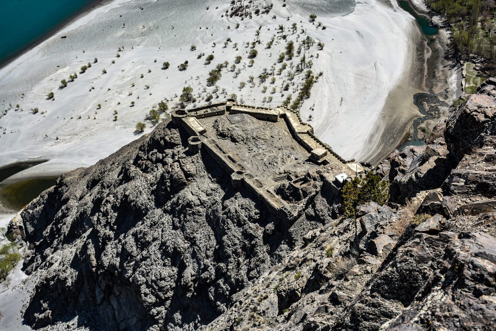
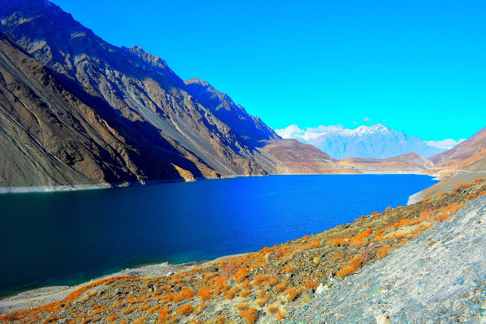
All three sites sit along the same short corridor south and east of Skardu town, following the road that eventually climbs to the Deosai Plains. Kharpocho Fort — Khar meaning “fort” and Pocho meaning “king” in Balti, so literally the King of Forts — sits on a rock spur directly above the confluence of the Indus and Shigar rivers, inside the town itself. A short drive further out, the village of Manthal holds a granite boulder carved with a Buddha centuries before Islam reached Baltistan. Continue on the same road and it climbs gently to Satpara Lake, the glacial-blue reservoir that supplies Skardu’s drinking water and irrigation. None of it requires a jeep with low range or a Baltoro-grade level of fitness — just a driver who knows the road and enough daylight to do all three without rushing.
What ties the loop together is less the geography than the history. The same 16th-century king credited with building the fort is, by tradition, also credited with damming the lake — and the Buddha at Manthal predates both of them by roughly 800 years. We’ll get to that.
The route, stop by stop
- Kharpocho Fort (morning, first stop). Start early, before the sun is directly overhead on the stairway. The climb from the base to the fort takes 15–20 minutes up an uneven, partly loose stone path — steep in places, with no railings on some sections.
- The ramparts and the view. At the top, the ruined walls look straight down over Skardu town, the Indus River, and the confluence with the Shigar. The ruins of the Mendoq Khar palace, built for the fort-builder’s Ladakhi queen, sit just below.
- Drive to Manthal village (around 10 minutes from central Skardu, on the road toward Sadpara/Satpara).
- Manthal Buddha Rock. A short walk from the road to the carved rock face — allow 20–30 minutes to look properly and hear the history.
- Continue toward Satpara Lake — about 7 km and roughly 30 minutes further along the same road, gaining altitude gradually as the valley narrows.
- Satpara Lake. Time by the water — a walk along the shore, tea at one of the lakeside stalls, sometimes a short boat ride when boats are running. This is also the turn-off point for Deosai if you’re continuing that way another day.
- Return to Skardu the same way, usually arriving back by mid-to-late afternoon.
500 years in an afternoon
Kharpocho Fort’s earliest structure was raised at the end of the 16th century by Ali Sher Khan Anchan (also recorded as Ali Senge Anchan, r. c.1595–1633), the Balti king remembered for uniting Baltistan under the Maqpon dynasty for the first time. Tradition also credits the same king with damming Satpara Lake, while his Ladakhi queen, Mandok Gyalmo, is said to have taken a channel from it to irrigate her gardens — which is why the fort and the lake, though built for different purposes, trace back to the same royal household.
The fort itself had a harder 19th and 20th century than its founder could have guessed. It remained the seat of the Maqpon dynasty until the last of its rulers, Ahmad Shah, fell to the Dogras in the 19th century; in 1840, the Dogra general Zorawar Singh stormed and razed it during his invasion of Baltistan. Nearly a century later, the fort area was besieged again during the First Kashmir War of 1947–48, when Jammu and Kashmir State Forces held out for close to a year before surrendering on 14 August 1948, a year after Pakistan’s independence.
Manthal Buddha Rock
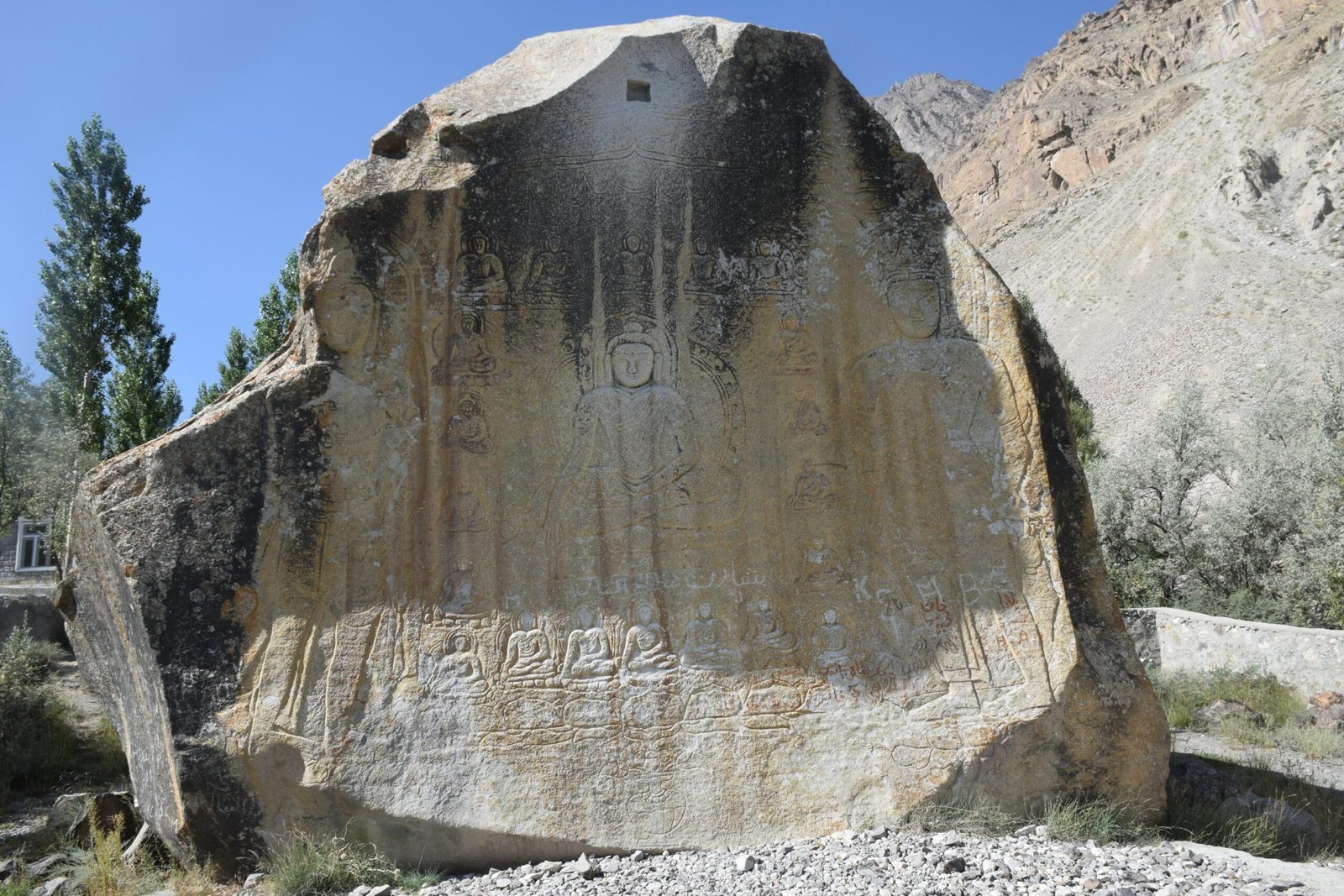
Manthal Buddha Rock belongs to an older Baltistan altogether. The relief — a central Buddha surrounded by roughly twenty smaller Bodhisattvas and two standing Maitreyas, the “future Buddhas” — was carved into the granite face probably in the 8th century, when the majority of the region’s population was Buddhist, centuries before Islam reached Baltistan. It sat unremarked by the outside world until 1906, when the Scottish traveller Ella Christie described it in a book on her journey through Western Tibet and gave it its first international attention. It is one of the most important surviving relics of Buddhism anywhere in Baltistan.
When to go
| Months | Conditions | Verdict |
|---|---|---|
| March–May | Snow clearing at the fort and lake; road to Satpara reopens fully; cooler mornings | Good — fewer crowds, green valley starting to show |
| June–August | Warm, long daylight, Satpara Lake fullest and bluest | Best all-round window |
| September–October | Clear skies, golden poplars, cooling evenings | Excellent — our favourite light for photos |
| November | First cold snaps; fort stairway can ice over in shade | Fine with care, check conditions first |
| December–February | Snow and ice likely on the fort steps and the upper Satpara road; lake edges can freeze | Possible, but confirm road/site conditions the day before |
How hard is it, honestly
This is not a trek, and we won’t dress it up as one. The one physical demand is the climb to Kharpocho Fort: 15–20 minutes up a steep, uneven stone stairway with loose stone underfoot in places and no railing along parts of the route. It’s an easy climb for anyone reasonably fit and comfortable on uneven ground, and it is genuinely awkward in the wrong footwear or after rain or overnight frost. Manthal Rock and Satpara Lake involve nothing harder than a short walk from a parked vehicle. Altitude is a non-issue at these elevations for the vast majority of visitors — Satpara Lake at 2,600 m sits well below where altitude symptoms typically start. The honest caveats: midday sun at the fort with little shade, and a lakeside path at Satpara that can be slippery near the water after rain.
Safety, honestly
This is a low-risk day out, and we won’t pretend otherwise to sound dramatic — but “low risk” isn’t “no risk.” The Kharpocho Fort stairway is the main thing to respect: loose stone, uneven steps, unguarded edges in places, and it gets genuinely dangerous when wet, icy, or rushed. Take it slowly, wear real shoes, and skip it if the steps are visibly icy. At Satpara Lake, the water is cold glacial melt and currents near the dam intake are not for swimming. As with every trip we run — expedition or day tour — our vehicles carry emergency contacts and our team is trained to get you to help in Skardu quickly if something does go wrong. It’s part of how we operate, not a feature reserved for the big trips.
Permits & visa
Kharpocho Fort, Manthal Buddha Rock, and Satpara Lake all sit in an open tourism zone — no trekking or mountaineering permit is required, unlike the expedition valleys further up the Baltoro. A small entry ticket applies at the fort and at the Manthal Rock site, payable on arrival. Foreign visitors need Pakistan’s standard tourist visa for this day — not the separate Trekking & Mountaineering visa required for expedition clients heading to K2 or the Gasherbrums; see our Pakistan visa guide for the current requirements. Because Satpara Lake feeds Skardu’s drinking water supply through Satpara Dam, swimming and washing near the lake are discouraged out of basic respect for the town’s water source, not park rules.
Getting there & what it costs
You’ll need transport for the day rather than your own legs — a private vehicle with a driver who knows the fort stairway’s condition that week and whether the Satpara road is clear. If you’re flying or driving in for the first time, our guide to getting to Skardu covers both routes from Islamabad. We keep pricing personal rather than posting a number here that goes stale by the time you read it — message us with your dates and group size and we’ll quote a fair price, no corners cut on the vehicle, the driver, or the guide who’ll walk you through the history at each stop.
A day in town is the start, not the trip. Our 6-day Skardu Tour Package wraps Kharpocho and the bazaar into a full week with Shigar, Deosai and Khaplu from $480 per person — or keep it light with the 5-day Skardu City Tour from $350.
Want this day done for you? Our Manthal Buddha Rock & Skardu Heritage Walk covers Kharpocho, the bazaar and the Buddha with a local guide and every ticket handled, from $40 per person. Add the lakes with the Shangrila & Kachura Lakes Day Tour from $65.
Frequently asked questions
How long does the Skardu day tour take?
Plan on 5–6 hours for all three stops with an unhurried pace, including the fort climb, driving between sites, and time at the lake. It can be tightened to a half-day if you skip lingering at Satpara, or stretched into a full day with lunch by the water.
Is Kharpocho Fort hard to climb?
No technical difficulty, but it is a genuine 15–20 minute climb up a steep, uneven stone stairway with loose stone in places and no railing on some sections. Reasonable fitness and proper shoes are all you need; care is needed if it’s wet or icy.
Do I need a permit for Kharpocho Fort, Manthal Rock, or Satpara Lake?
No trekking or mountaineering permit is needed — this is an open tourism zone. You do need a standard Pakistan tourist visa, and small entry tickets apply at the fort and the Manthal Rock site.
Can I combine this with Deosai or a bigger trek?
Yes — Satpara Lake sits on the road toward Deosai, so this loop works well as the first half of a longer day heading to the Deosai jeep safari, or as an easy acclimatisation-and-culture day before or after a K2 Base Camp trek.
Is Satpara Lake worth it if I’ve already seen Shangrila and Kachura Lakes?
Yes — it’s a different kind of lake. Satpara is a working reservoir tied into Skardu’s water supply, sitting higher and starker than the more manicured Shangrila and Kachura lakes, with the Deosai road climbing away from its far end. Most of our clients do both; they don’t feel repetitive.
Plan your Skardu day loop with a local Balti team, not a broker. WhatsApp us at +92 312 9921574 or email info@karakoramventure.com with your dates — we’ll build this into your itinerary or run it as a standalone day.
Sources & attribution: Wikipedia entries for Skardu Fort, Manthal Buddha Rock, and Satpara Lake. Photographs: Kharpocho Fort by Hannan Balti (CC BY-SA 4.0); Manthal Buddha Rock by گمنام سپاهی / Gumnam Sapahi (CC BY-SA 4.0); Satpara Lake, Wiki Loves Earth Pakistan 2015 contributor (CC BY-SA 3.0) — all via Wikimedia Commons.

