The Charakusa Valley is a granite amphitheatre at the head of the Hushe Valley in Gilgit-Baltistan, ringed by K6 (7,281 m), K7 (6,934 m) and Link Sar (7,041 m). You reach the K6 and K7 base camps on a short but serious trek from Hushe village — roughly 6–9 days door-to-door, topping out around 4,500–4,600 m on glacier terrain. The season is June to September. It is one of the most rewarding introductions to high Karakoram trekking, but the upper valley is still glacier country and should be walked with a local team.
We run the Charakusa out of the Hushe Valley with our own Balti team — the same valley our Masherbrum (K1) and Laila Peak treks share. Here is the honest, fully-researched guide: where it is, what you actually walk, the giants you stand beneath, the season, the difficulty and the safety realities — with the numbers checked against primary sources.
Key Takeaways
- Where: head of the Hushe Valley, Masherbrum Range, Gilgit-Baltistan — reached on foot from Hushe, the road-end village (~3,050 m).
- The giants: K6 (7,281 m), Link Sar (7,041 m), K7 (6,934 m), plus Kapura, Drifika and a forest of granite spires.
- Base camps: K6 and K7 base camps sit around 4,500–4,600 m on the Charakusa Glacier.
- Duration: roughly 6–9 days door-to-door; the walk in from Hushe is about two days.
- Difficulty: moderate — non-technical, but real altitude and glacier ground; a strong introduction to Karakoram trekking.
- Season: June to September, with July–August the most stable.
Where is the Charakusa Valley?
The Charakusa branches east off the Hushe Valley, the long glacial trough that runs south from the Shyok river in Baltistan. Hushe is the road-end — the last village before the mountains take over, the same trailhead used for Masherbrum Base Camp and for the Hushe side of the Gondogoro La. From Hushe you walk in past the herders’ settlement of Saicho (~3,350 m) and up onto the Charakusa Glacier, into a basin so packed with sheer granite that climbers have spent whole careers here.
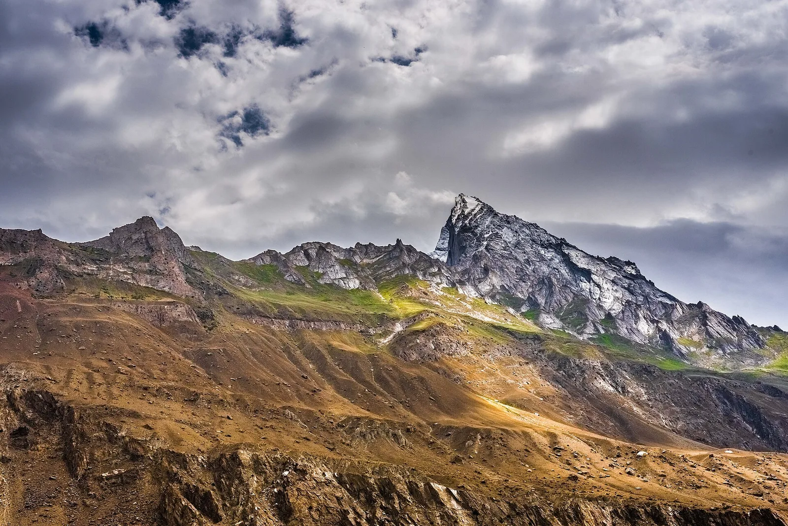
The giants of the Charakusa
This is why people come. The valley is closed at its head by some of the most striking rock-and-ice peaks in the Karakoram. K6 is the high point at 7,281 m; Link Sar (7,041 m) was one of the last great unclimbed seven-thousanders in the range until a first ascent in 2019; and K7 (6,934 m) rises as a single, clean granite tooth above the glacier.
The Yosemite of the Karakoram
Among alpinists, the Charakusa has near-mythic status. Its walls are clean, steep granite — closer to Yosemite or Patagonia than to the choss of most big ranges — and the world’s best climbers have come here for decades. The most famous chapter: in July 2004 the American alpinist Steve House soloed a new 2,400-metre route on K7’s south face in a single 41-hour push from base camp, a climb that won him Climbing magazine’s Golden Piton and the Piolet d’Or’s Prix du Public.
You do not need to be House to feel it. As a trekker you walk to the foot of these walls and camp beneath them — the same granite, the same silence, without the climb. If a clean spire above a glacier is your idea of a perfect camp, this valley belongs on your list alongside Laila Peak and the Concordia amphitheatre.
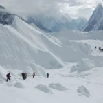
The route: Hushe to the K6 & K7 base camps
The walk is short by Karakoram standards, which is exactly why it makes such a good first high trek. You leave the road at Hushe and gain the glacier over a couple of days, sleeping at grassy camps before the ice.
A typical itinerary (on-trail)
- Day 1 — Hushe to Saicho (~3,350 m). An easy valley walk through fields and willow groves to the meadow camp at Saicho, the gateway to the Charakusa.
- Day 2 — Saicho to Spangsar / Charakusa camp (~4,000 m). Up onto the glacier’s edge, granite towers opening on every side, to a camp below the head of the valley.
- Day 3 — K7 & K6 base camps (~4,500–4,600 m). Explore the upper glacier and the base camps beneath the great walls; a layover day here is well spent.
- Days 4–6 — Return. Retrace to Hushe, with a buffer day for weather, acclimatisation or a second morning under the spires.
It is the same Hushe approach you would use for Masherbrum, which makes the two easy to combine into one longer Hushe trip.
Trek elevation profile
Safety reality: the upper Charakusa is a live glacier — crevasses, moving ice and rockfall off the walls are all real. The walk is non-technical, but the ground is not benign, and you are days from the nearest road. We carry a satellite phone and a real evacuation plan on every high trek, and we never put a group on the ice without a guide who knows the current route. Local hands, real safety, fair price.
When to go: season & weather
The window is June to September, the same broad summer season that opens the best treks in Pakistan. Before June, snow lingers on the upper glacier; after September the cold and early storms close the high camps. July and August give the most stable weather and the clearest mornings under the walls.
| Month | Conditions | Verdict |
|---|---|---|
| Apr–May | Snow on the glacier, unsettled weather | Too early |
| June | Opening up, green meadows, some lingering snow up high | Good, with a guide |
| July–Aug | Most stable, clearest walls, warmest camps | Best |
| September | Crisp, quiet, cold nights; weather turning | Good, late-season |
| Oct–Mar | Snowbound, high camps closed | Closed |
How hard is it? Fitness, altitude & the glacier
Honest answer: moderate. The Charakusa is one of the shorter, less punishing routes to a Karakoram base camp, which is why we recommend it as a first high trek. There is no pass to force, no technical climbing — but you still sleep at altitude on a glacier and walk 5–7 hours on the longer days over moraine and ice. A turned ankle up there is a serious matter far from help.
Altitude is the thing to respect. Coming straight from low elevation to 4,600 m invites acute mountain sickness, so we build in acclimatisation and watch every client. If you are new to high trekking, read our acclimatisation guide for the Karakoram first, and pack for genuine cold and high-altitude sun — our Karakoram trek packing list covers exactly what you need.
Permits & access note: the Charakusa trek to the K6/K7 base camps is an open-zone trek and does not need the special mountaineering permit that the peaks themselves require — but you do need the correct Pakistan visa, and rules can change. Foreign trekkers should check our Pakistan visa guide and confirm any local registration with us before travel. Climbing K6, K7 or Link Sar is a different matter and needs a full mountaineering permit.
Getting there & what it costs
Hushe is on the Baltistan side of Gilgit-Baltistan, reached by jeep from Skardu via Khaplu. Start with how to get to Skardu and our wider Skardu travel guide for the logistics; from Skardu it is a long, scenic drive up the Shyok to the road-end. Many trekkers fold the Charakusa into a wider Baltistan trip that also takes in Masherbrum, the Sarfaranga cold desert or the Baltoro and Concordia.
Costs depend on group size, days and service level, so we keep pricing personal rather than posting a number that goes stale. What we promise: a fair price with no corners cut on guides, food or safety gear. WhatsApp us for current 2026 dates and a quote.
Ready to plan the real thing? WhatsApp us for the Charakusa Valley route, inclusions and how we run it with a local Balti–Hushe team.
Frequently asked questions
How high are K6 and K7?
K6 is approximately 7,281 m and K7 approximately 6,934 m. They stand at the head of the Charakusa Valley alongside Link Sar (7,041 m). The trek takes you to their base camps at around 4,500–4,600 m, not to the summits.
How many days is the Charakusa Valley trek?
Most parties spend about 6–9 days door-to-door, with roughly two days walking in from Hushe to the base camps and a buffer day for weather and acclimatisation. It is one of the shorter base-camp treks in the Karakoram.
Is the Charakusa trek difficult?
It is moderate and non-technical, which makes it a good first high-altitude trek — but you still camp near 4,600 m on a live glacier and walk several hours a day over moraine and ice. Good fitness, proper acclimatisation and a guide are essential.
When is the best time to trek the Charakusa?
June to September. July and August are the most stable for clear mornings under the walls; June and September are quieter and colder, with more chance of lingering or early snow.
Do I need a permit for the Charakusa Valley?
The trek to the K6/K7 base camps is in an open trekking zone and does not require the special mountaineering permit needed to climb the peaks. You still need the correct Pakistan visa, and should confirm any local registration with your operator before travel.
Plan your Charakusa Valley trek
Want to camp beneath K6 and K7 in the granite heart of the Karakoram? WhatsApp us on +92 312 9921574 or email info@karakoramventure.com — you’ll be talking to a local Balti team, not a broker. We’ll sort dates, group size, acclimatisation and safety, and walk you to the base camps the right way.
Sources & attribution: peak elevations and geography from Wikipedia and published mountaineering references (K6, K7, Link Sar, Hushe); Steve House’s 2004 K7 solo from American Alpine Club / Alpinist reporting. Figures are approximate where sources differ. Altitudes for camps and base camps vary slightly between operators and seasons.