



Skyang Kangri, also called Staircase Peak, is a 7,545 m mountain in the Baltoro Muztagh, standing on the Pakistan–China border about 7 km north-east of K2. There is no trekking route to its summit and no commercial expedition on it — it has been climbed once, by a Japanese team in 1976, and the Himalayan Index records no attempts since 2008. What travellers can realistically do is walk beneath it: the standard K2 Base Camp trek from Askole up the Baltoro and Godwin-Austen glaciers puts you directly under its west face in roughly 14–21 days, between June and early September.
We run this ground out of Skardu with our own Balti team, and we will be straight with you: most people who ask us about Skyang Kangri are not asking to climb it. They have seen the name on a Baltoro panorama, or read about the five-step ridge, and they want to know what it is and how close they can get. This guide answers that honestly — the mountain, the short and unusual climbing record, and the trek that actually gets you to its foot.
Key Takeaways
- Height: 7,545 m — the 20th highest peak of the Karakoram.
- Where: Baltoro Muztagh, on the Pakistan–China border, about 7 km north-east of K2, above the Godwin-Austen Glacier.
- The name: “Staircase Peak” describes the East Ridge, which rises in five distinct steps.
- First ascent: 1976, by a Japanese expedition, via the East Ridge — 67 years after the first attempt.
- Climbing status: extremely rare. Attempts in 1909, 1975, 1976, 1980 and 2008; the West Face remains unclimbed.
- What you can book: not a summit — a trek beneath it, via Concordia and K2 Base Camp, roughly 14–21 days from Skardu, June to early September.
Where Skyang Kangri is, and why it matters
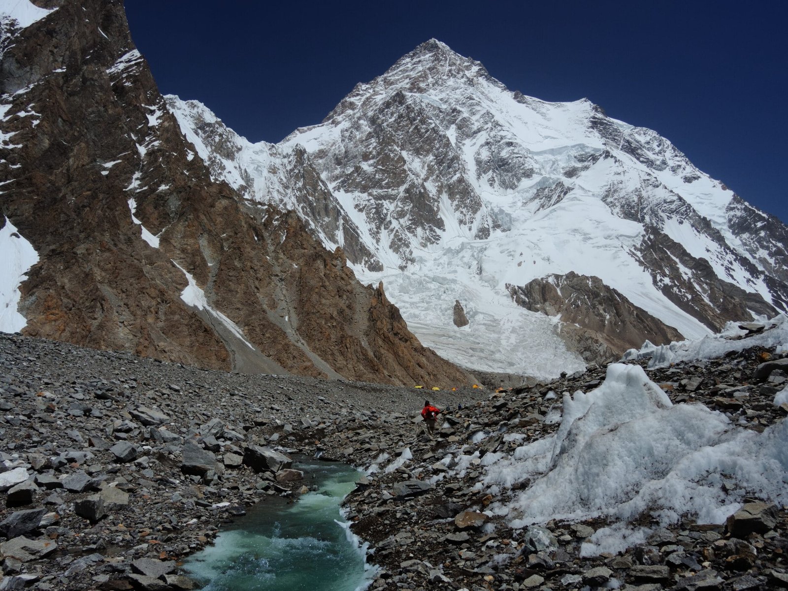
Stand at Concordia and turn north. The Baltoro Glacier hands you over to the Godwin-Austen Glacier, which runs up towards K2 Base Camp. K2 fills the head of that corridor. Skyang Kangri sits about 7 km beyond it to the north-east, on the frontier ridge with China, and it closes the valley at the top.
Between the two lies Windy Gap — a 6,111 m saddle east of K2, north of Broad Peak and south of Skyang Kangri. The name is not decorative. It is the notch that funnels wind off the Shaksgam side, and it is the reason the upper Godwin-Austen is one of the coldest places on the trek.
The mountain is geologically odd, too. Its summit and northern slopes are Shaksgam Formation limestone — shallow-marine, fossil-bearing rock, laid down in a Permian sea — while K2 itself, a few kilometres away, is gneiss. You are looking at a seabed pushed to 7,545 m, sitting next to the second-highest mountain on earth.
Schematic comparison. Bars are scaled for readability, not to a true zero baseline. Elevations approximate.
The route: how you actually get beneath it
There is no trek to the summit of Skyang Kangri and no guided climb on it. The realistic objective is the K2 Base Camp trek, which ends on the Godwin-Austen Glacier with Skyang Kangri closing the head of the valley. Here is the standard shape of it from Skardu.
- Skardu to Askole — 4×4 jeep up the Braldu gorge, roughly 7–9 hours on a rough road. Last village, last mobile signal.
- Askole to Jhola — a long valley day on river terraces, crossing to the north bank.
- Jhola to Paiju — the first proper view of Paiju Peak and the snout of the Baltoro. A rest day here is normal and worth taking.
- Paiju to Khoburtse or Urdukas — you step onto the glacier. Moraine, meltwater channels, slow going.
- Urdukas to Goro II — out on the open ice under the Trango Towers and the Muztagh Tower.
- Goro II to Concordia — the confluence. K2, Broad Peak and the Gasherbrums all at once.
- Concordia to K2 Base Camp and back — up the Godwin-Austen at around 5,150 m. This is where you stand under Skyang Kangri and can trace the Staircase ridge and Windy Gap.
- Return — either back down the Baltoro, or over the Gondogoro La (5,585 m) into Hushe if your team is equipped for it and conditions allow.
Figure on 14 days minimum for the out-and-back, 18–21 with the Gondogoro La crossing and sensible weather buffer. Full route detail and costing sit in our K2 Base Camp trek guide.
Schematic and approximate. Stage lengths and camps vary with conditions and the pace of your group.
The Staircase: one summit in a century of trying
Skyang Kangri has one of the thinnest climbing records of any 7,500 m peak in the Karakoram. The story runs like this.
1909. Luigi Amedeo, Duke of the Abruzzi, brought his K2 expedition into the Godwin-Austen and attempted the East Ridge. They failed, but the expedition photographer Vittorio Sella came away with the images that first showed the world what this valley looked like.
1975. Another attempt on the East Ridge, and the mountain took its price: one climber died, and another had to be flown out by helicopter.
1976. A Japanese expedition finally climbed the East Ridge and reached the summit — the first and, so far, the only ascent. Sixty-seven years after the Duke first tried.
1980. Jeff Lowe and Michael Kennedy went at the West Face and got to roughly 7,100 m before Lowe developed altitude sickness and they retreated.
2008. A Russian team reached the headwall at around 7,000 m on the same West Face line, then a heavy snowstorm and illness in the team ended it. The Himalayan Index records no attempts since.
That is the whole file. One summit, an unclimbed West Face, and nobody up there for well over a decade — on a mountain in plain sight of the busiest base camp in the Karakoram.
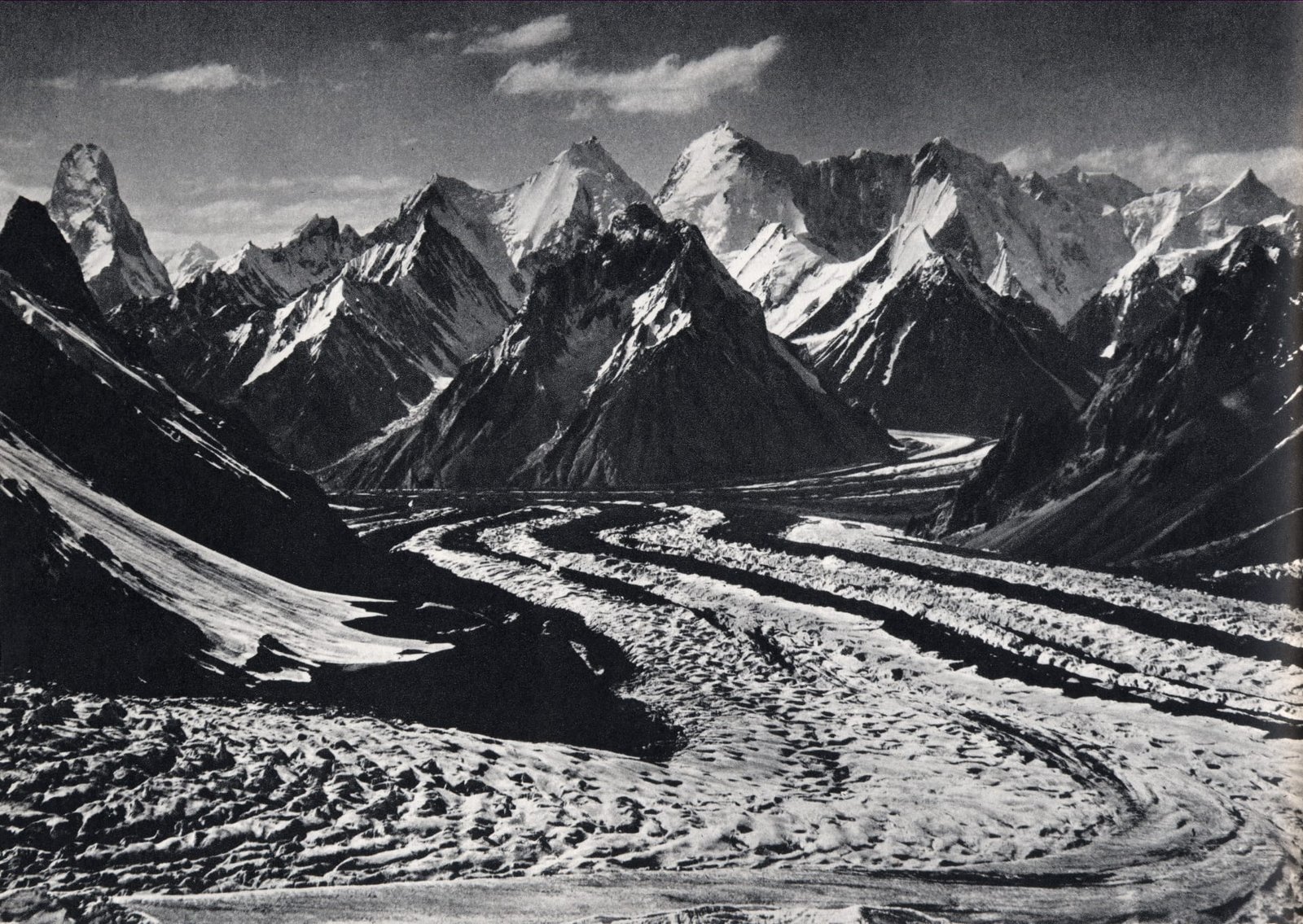
The view: what you actually see from the Godwin-Austen
From K2 Base Camp the mountain reads as a long white wall rather than a spire. It does not have the drama of the Muztagh Tower or the sheer arrogance of K2. What it has is scale and stillness. It is the far end of the room.
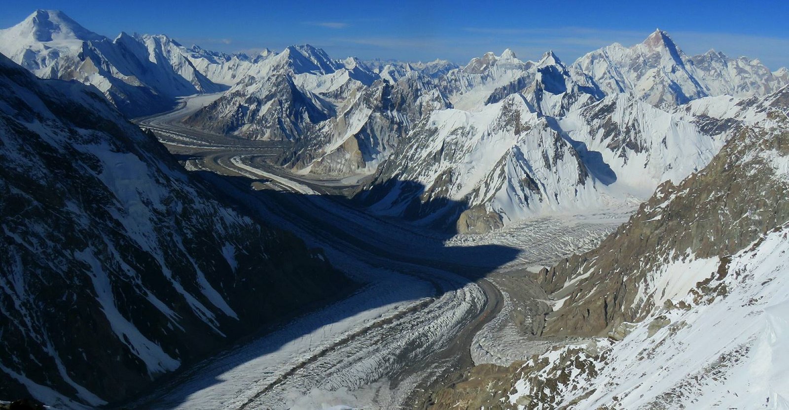
The Staircase itself is best picked out in early light, when the five steps of the East Ridge throw shadows across each other. From directly below on the glacier, foreshortening flattens it — walk a little further down-valley towards Broad Peak Base Camp and it opens up. Bring a long lens if you care about it; our Karakoram photography guide covers what works up there.
When to go
The Baltoro has a short, hard season. Outside it, the jeep road and the glacier both stop cooperating.
| Months | Conditions | Verdict |
|---|---|---|
| Nov–Apr | Deep winter on the glacier; Askole road frequently blocked; camps closed. | Not viable |
| May | Snow still low on the trail, cold nights, high river flow from early melt. | Early and unsettled |
| June | Route opening up, fewer groups, still cold at Concordia and above. | Good, for those who want quiet |
| July–August | Peak season. Warmest conditions, expedition teams on the Godwin-Austen, most reliable weather windows. | Best overall |
| Early September | Cold returns, clear light, thinning crowds. Weather windows shorten fast. | Very good, with buffer days |
| Late Sept–Oct | Season closing, serious cold at altitude, staff and camps withdrawing. | Closing — specialists only |
More detail on how the mountains up there run their year is in our Baltoro climbing season guide.
How hard is it, honestly
Climbing Skyang Kangri is not a commercial proposition and we will not pretend otherwise. It is a remote, rarely visited 7,500 m peak with one ascent, a dangerous East Ridge history and an unclimbed West Face. That is expedition-alpinist territory: your own team, your own permit, your own risk assessment. We can provide base camp logistics and porterage for a serious team, and we will say no to anyone who is not one.
Trekking beneath it is a different question, and the honest answer is: hard, but achievable if you prepare. Not technical — no ropes or ice axes on the standard K2 BC out-and-back — but long. You will walk 6–8 hours a day for two weeks, much of it on unstable moraine and glacier ice, sleep at 4,000–5,000 m, and be cold most nights. The altitude does more damage than the terrain; read our acclimatisation guide before you book anything, and see the K2 packing list for what actually keeps you warm up there.
If you have not done a multi-day high-altitude trek before, this should not be your first. It can be your second.
Safety: the real risk on the Godwin-Austen
The dangers here are altitude illness, crevasses and rockfall on moraine, and cold — in that order of likelihood. The 1975 Skyang Kangri accident ended in a helicopter evacuation, and that is still what a serious problem looks like on this glacier: there is no road, no clinic, and no walking someone out quickly from 5,150 m. We carry a satellite phone on every expedition and trek, work with established helicopter-rescue contacts for the Baltoro region, and require every client to hold high-altitude evacuation insurance. We say this plainly because budget operators quietly cut it, and you only find out when it matters.
Permits and access
The K2 Base Camp trek runs through an open zone and does not require a mountaineering permit — a registered operator, a licensed guide and standard trekking formalities cover it. Any attempt on Skyang Kangri itself is a different matter: it is a border peak on the Pakistan–China frontier, which means a formal mountaineering permit and additional clearances that must be arranged well in advance. Either way, you will need a Pakistan visa — and for trekking and climbing that is the Trekking & Mountaineering visa, not a standard tourist visa. Our Pakistan visa guide for trekkers walks through it.
Getting there, and what it costs
Everything starts in Skardu. Fly Islamabad–Skardu when the weather allows — it is under an hour and one of the great flights anywhere — or come overland, which is longer and needs buffer days built in. Our how to get to Skardu guide compares both properly. From Skardu it is the jeep to Askole, and then you walk.
On cost: we keep pricing personal rather than posting a number that goes stale the moment porter rates, permit fees or fuel move. Tell us your dates, group size and whether you want the Gondogoro La crossing, and we will send you a real breakdown — a fair price, with nothing cut out of the guiding, the food or the safety kit to get there. If you are weighing this against Nepal, our K2 vs Everest Base Camp comparison lays out both sides.
You can stand under it. Skyang Kangri’s west side looks straight down on K2 Base Camp, and getting there is a trek, not a climb. Our 14-day K2 Base Camp Trek Light goes Askole to Concordia and the Godwin-Austen Glacier at about 5,150 m and back, from $1,800 per person. The 21-day K2 Base Camp Trek Classic walks the same route at a fuller acclimatisation pace, from $2,300, and the 21-day K2 Base Camp and Gondogoro La Trek exits over the 5,585 m pass to Hushe, from $2,600. Balti guides and porters from Askole, permits handled, sat phone in camp. It is cold, it is long, and the moraine is relentless. Better you know that now than at Urdukas.
Frequently asked questions
How high is Skyang Kangri?
Skyang Kangri is 7,545 m (24,754 ft), making it the 20th highest peak in the Karakoram range. It stands on the Pakistan–China border in the Baltoro Muztagh, about 7 km north-east of K2.
Why is it called Staircase Peak?
The name refers to its East Ridge, which rises in five distinct steps and looks like a giant staircase from the Godwin-Austen Glacier. That ridge is also the mountain’s only successful route: it was climbed by a Japanese expedition in 1976.
Can I climb Skyang Kangri on a commercial expedition?
No. There is no commercial expedition on Skyang Kangri. It has one recorded ascent (1976), a fatal accident on the East Ridge in 1975, an unclimbed West Face, and no recorded attempts since 2008. It is a project for a self-sufficient alpine team with its own permit, not a guided climb. We can supply base camp logistics for a serious expedition.
How close can a trekker get to Skyang Kangri?
You can stand directly beneath its west side at K2 Base Camp, around 5,150 m on the Godwin-Austen Glacier. That is reached on the standard K2 Base Camp trek from Askole via Concordia — roughly 14 days out and back, or 18–21 days if you cross the Gondogoro La to Hushe.
What is Windy Gap?
Windy Gap is a 6,111 m pass east of K2, north of Broad Peak and south of Skyang Kangri, on the frontier ridge. It funnels wind down onto the upper Godwin-Austen Glacier, which is part of why K2 Base Camp is so cold. It is not a trekking route.
Walk the Godwin-Austen with a local team
We are a Balti company in Skardu, not a broker. Our guides grew up in these valleys, our porters are from Askole and the Braldu villages, and nobody hands you over to a third party halfway up the glacier. Sat phone in camp, a rescue plan that actually exists, and a fair price.
WhatsApp +92 312 9921574 — message us “K2 BC” for 2027 dates · Email info@karakoramventure.com
Sources & attribution: elevation, geology, first-attempt and first-ascent details from Wikipedia (Skyang Kangri) and the American Alpine Journal (Kennedy, 1981; Zakharov, 2009); attempt record cross-checked against the Himalayan Index. Images: Zacharie Grossen (CC BY-SA 4.0), Vittorio Sella (public domain) and Syed Hasan Shabbar (CC BY-SA 4.0), all via Wikimedia Commons. Figures are approximate and route timings vary with conditions.

