



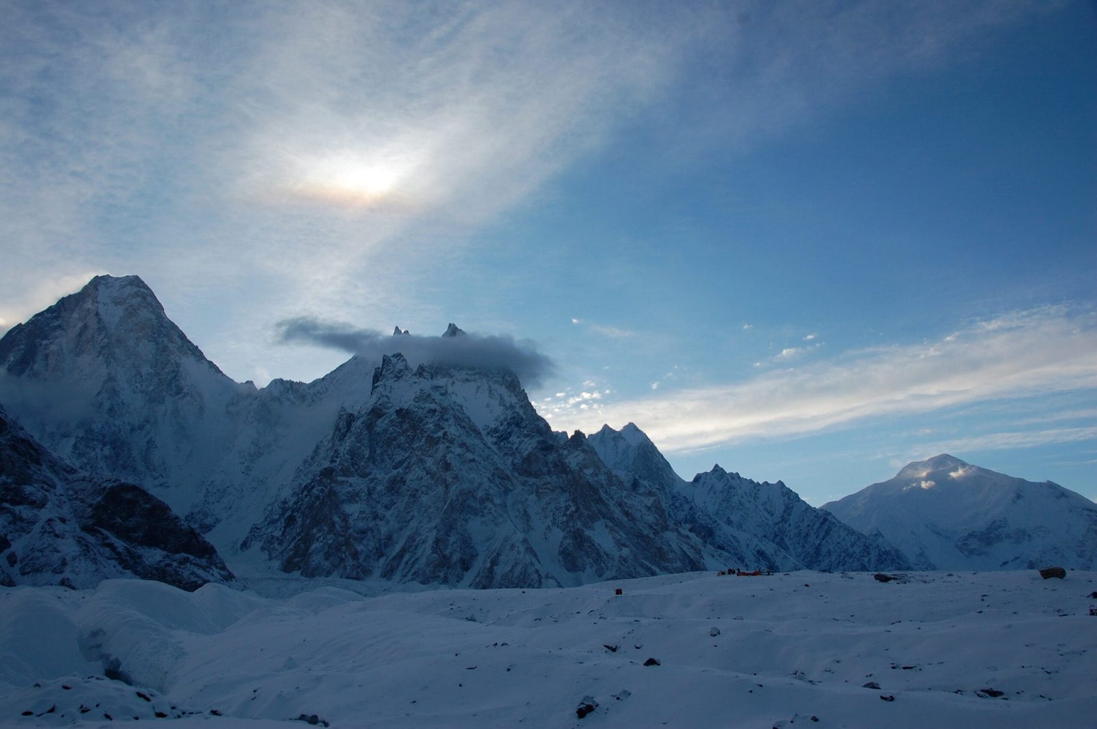
Gasherbrum VI is a 6,979 m peak at the head of the Baltoro Glacier in Gilgit-Baltistan, Pakistan, and it is the only mountain in the Gasherbrum group that nobody has climbed. It stands on a ridge south of the main Gasherbrum crest, reached from Skardu by jeep to Askole and then seven to nine days on foot up the Baltoro, past Concordia. The climbing window is short — roughly mid-June to early September. This is not a trekking peak: five recorded attempts have been turned back by unprotectable rock, sugar snow and avalanche danger, and one climber has been killed on it.
We run the Baltoro out of Skardu with our own Balti team, and we will be straight with you. Gasherbrum VI is not a package we sell to anyone who asks. It is an unclimbed 7,000 m-class objective for a small, self-sufficient team that already knows how to move on bad snow over compact rock, a long way from help. What we do is get that team to the foot of the mountain properly — permits, porters, base camp, food, a satellite phone and a rescue plan that exists on paper before you leave Skardu. If you are here to read about one of the last real prizes on the Baltoro rather than to climb it, that is fine too. It is a mountain worth knowing about.
Key takeaways
- Height: 6,979 m by the figure Wikipedia and PeakVisor carry. Climbers and the American Alpine Journal often quote about 7,004 m, so treat it as sitting right on the 7,000 m line.
- Status: unclimbed — the only unclimbed summit in the Gasherbrum group.
- Where: Baltoro Muztagh, Karakoram, Gilgit-Baltistan; on a ridge south of the main crest that runs west to Gasherbrum V and then north to Gasherbrum III.
- Prominence: about 549 m — modest, which is part of why it was numbered rather than named by surveyors.
- Access: Islamabad to Skardu, 4×4 to Askole, then roughly 100 km on foot. The 2016 team put base camp at about 4,800 m on the Baltoro.
- Season: mid-June to early September. It needs a mountaineering permit, not an open-zone trekking permit.
Where Gasherbrum VI sits — and what the name actually means
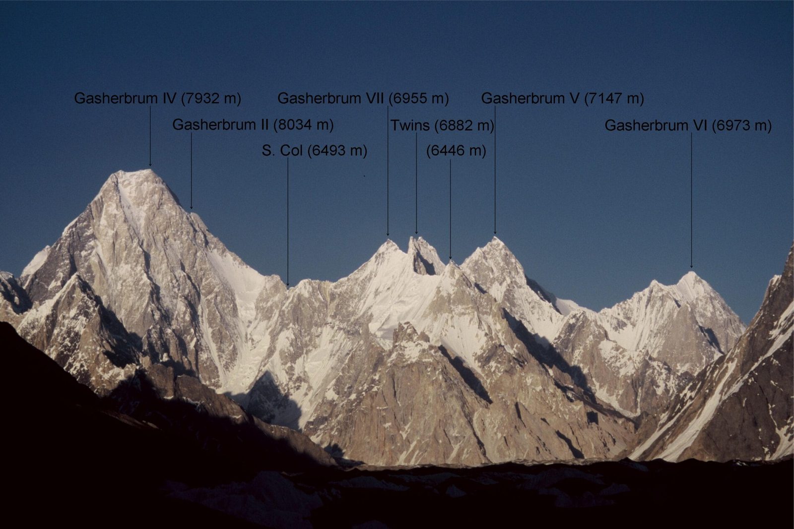
The Gasherbrum group sits at the north-eastern end of the Baltoro Glacier, straddling the border of Gilgit-Baltistan and Xinjiang. It holds three of the world’s eight-thousanders — Gasherbrum I and II and Broad Peak if you count it in — plus Gasherbrum III, the Shining Wall of Gasherbrum IV, and Gasherbrum V. Gasherbrum VI, also recorded as Chochordin Peak, is the quiet one at the end of the list — at 35°42’30″N, 76°37’54″E, on the ridge running south of the main crest.
People will tell you Gasherbrum means “shining wall”, because of Gasherbrum IV’s famous face catching the evening light above Concordia. It does not. The word comes from Balti — rgasha, beautiful, and brum, mountain. Beautiful mountain. Our own language named these peaks long before the Survey of India gave them K-numbers in 1856, and Gasherbrum VI never got one of those numbers at all: Thomas Montgomerie, sighting the range from over 200 km away, could only pick out the biggest heads in the crowd.
That is worth holding onto when you look at the mountain. It is not obscure because it is small or dull. It is obscure because it stands behind giants, and because everyone who has gone to climb it has come home without the summit.
How Gasherbrum VI compares with its neighbours
Schematic and approximate. Elevations as listed on Wikipedia’s Gasherbrum group table; several of these figures vary by a few metres between sources.
The approach: Skardu to the foot of the mountain
There is no shortcut. You walk in on the same road and the same glacier as everyone heading for K2 Base Camp or the Gasherbrum eight-thousanders. When Nancy Hansen and Ralf Dujmovits went in for the 2016 attempt, they covered more than 100 km on foot with a cook, a liaison officer, Balti porters, a few donkeys, eight chickens and two goats before they saw the mountain properly. That is what an expedition on this side of the Baltoro looks like.
- Islamabad to Skardu. Fly if the weather allows — it is under an hour and one of the great flights anywhere. Otherwise it is the long road up the Karakoram Highway. Build in buffer days either way; see our guide on getting to Skardu.
- Skardu. Permit paperwork, load-making, gear check, meeting the liaison officer. Usually one to two days.
- Skardu to Askole by 4×4, roughly 7–9 hours on a rough, exposed jeep road. Last village, last shop, last mobile signal.
- Askole to Jhola along the Braldu river — hot, dusty, long.
- Jhola to Paiju, with the Trango group and Paiju Peak coming into view.
- Rest day at Paiju. Porters bake bread, the team acclimatises. Do not skip it — see our acclimatisation guide.
- Paiju to Khoburtse or Urdukas, stepping onto the Baltoro itself.
- Urdukas to Goro II, out on the open glacier with the Gasherbrums ahead.
- Goro II to Concordia, where the Godwin-Austen and Upper Baltoro glaciers meet under K2.
- Concordia towards the Gasherbrum side, and base camp on the glacier at around 4,800 m, south-west of the peak.
From base camp, the mountain has no easy side. The 2016 pair found a way through the lower icefall into the valley south-west of the peak, slept at 5,300 m, then climbed a broad snow and ice couloir to a high camp at about 6,200 m on the south-west ridge.
Five attempts, no summit
The record on Gasherbrum VI is short and consistent — people get high, then find nothing they can protect.
- 1985 — a disputed claim. The Italian climber Maria Luisa Ercalini claimed a solo ascent by the south-east face. It is now widely discounted.
- 1993 — Walter Hölzler, solo. The German alpinist left base camp at midnight and got to within 200 m of the summit cornice on the roughly 1,700 m south-east face before the sun overheated it and the snow began sliding on the rock slabs beneath. He turned round.
- 1998 — the French attempt. Nicolas Bonhomme, Jean-Paul Cache and Jean-Noël Urban went for the same face, intending to ski it. They reached about 6,900 m. Bonhomme was swept away by a small avalanche and killed.
- 2009 — Portugal. Paulo Roxo and Daniela Teixeira tried the north-east face and east ridge from the South Gasherbrum Glacier and stopped 60 m below the ridge in poor conditions.
- 2016 — Dujmovits and Hansen. From the 6,200 m col on the south-west ridge they tried two lines through the rock band above. Both ended the same way: a few centimetres of sugar snow lying over compact, steep, unprotectable marble, with no way to build even a marginal belay. They judged the risk unacceptable and went down.
Hansen’s own summary in the American Alpine Journal was blunt: the only remaining option is the avalanches, seracs and cornices of the north-east face, which she called an unappetising proposition. Ten years on, nobody has proved her wrong.

When to go
The Baltoro season is short and the good conditions inside it are shorter. One thing the 2016 attempt made clear: on Gasherbrum VI’s east-facing slopes the snow went isothermal soon after the sun hit it at about 4 a.m., and the nights were not freezing hard enough to fix it. Heat, not cold, is the enemy here.
| Months | Conditions | Verdict |
|---|---|---|
| April – May | Deep snow low on the glacier, unsettled weather, porters reluctant, jeep road to Askole often still being cleared. | Too early for this side of the Baltoro. |
| June | Approach becomes reliable, nights still freeze properly higher up, glacier travel firmer. | The strongest window for a serious attempt. |
| July | Warmest and most settled for the eight-thousanders. On Gasherbrum VI, slopes soften within an hour or two of sunrise. | Good for the walk in, poor for the snow above 6,000 m. |
| August | Hot early, cooling towards the end; crevasses wide open, glacier travel slower. | Workable late in the month if the freeze returns. |
| Early September | Cold nights come back, days shorten, weather turns fast. | Short, sharp window — and plan the walk out carefully. |
| October – March | Winter. The road, the porters and the glacier all shut down. | Not viable. |
For how this fits with the wider Baltoro calendar, read our piece on the climbing season on the Baltoro.
How hard is it, honestly
Schematic and approximate. Camp altitudes follow the 2016 attempt; village and campsite heights are the commonly quoted figures and vary slightly between sources.
Fitness. The approach alone is two weeks of load-sharing, glacier walking and cold nights before any climbing starts. If you are not comfortable doing the K2 Base Camp trek carrying your own kit, you are not ready for the mountain behind it.
Altitude. Base camp at 4,800 m is higher than most people’s previous personal record. You need real acclimatisation and a rotation plan, not enthusiasm.
Terrain. This is the part that stops everybody. The 1993, 1998 and 2016 attempts all ran into the same problem from different sides: steep ground where thin, faceted snow sits over compact rock, offering nothing to belay from. Skill on mixed and unprotectable terrain matters more here than lung capacity.
Who this is for. Experienced alpinists with previous Karakoram or Himalayan seasons behind them, going in small and light, with the judgement to walk away. Everyone else has a better time — genuinely — on the Concordia and Gondogoro La circuit.
Safety — say it plainly
A climber has already died on Gasherbrum VI. Avalanche on sun-loaded slopes is the named risk, and the ground above 6,200 m has repeatedly proved impossible to protect. Beyond that, you are days from a road. Every expedition we run carries a satellite phone in base camp, an evacuation plan written before departure, and established helicopter-rescue contacts for the Baltoro region — and we will not take a team in without insurance that actually covers high-altitude rescue. See our guide to insurance for high-altitude trekking in Pakistan. Budget operators cut this line first. We do not.
Permits and access
Walking the Baltoro to Concordia is an open-zone trek. Climbing Gasherbrum VI is not — any attempt on the peak requires a mountaineering permit, a liaison officer and royalty paid through the Pakistani authorities, and that paperwork takes months, not weeks. You will also need the correct visa: trekking and mountaineering visas are a separate category from the ordinary tourist visa. Start with our Pakistan visa guide for trekkers, then talk to us early — permit timelines are the single most common reason a Karakoram plan falls apart.
Getting there, and what it costs
Everything starts in Skardu. Fly Islamabad to Skardu when the weather cooperates, or take the Karakoram Highway and give yourself buffer days — either way, read how to get to Skardu first. From there it is jeep to Askole and then your own two feet.
On price: we keep pricing personal rather than posting a number that goes stale. An expedition on the Gasherbrum side of the Baltoro is priced on team size, days on the mountain, porter loads, permit and royalty, and what level of base camp support you want — those things move. Tell us the shape of your trip and we will quote it honestly: a fair price, with no corners cut on guides, food or safety. That is the whole of our pitch. Local hands, real safety, fair price.
Frequently asked questions
Has anyone climbed Gasherbrum VI?
No. It is the only unclimbed peak in the Gasherbrum group. A 1985 solo claim by Maria Luisa Ercalini is widely discounted, and the four documented attempts since — 1993, 1998, 2009 and 2016 — all turned back below the summit.
How high is Gasherbrum VI exactly?
Wikipedia and PeakVisor list 6,979 m. Climbers and the American Alpine Journal commonly use about 7,004 m, and Wikipedia’s own comparison table shows 7,001 m. The honest answer is that it sits within a few dozen metres of the 7,000 m mark and the surveys disagree.
Can I trek to Gasherbrum VI base camp without climbing?
You can walk the Baltoro to Concordia and on towards the Gasherbrum side, which puts you under the peak. That is a trek, on an open-zone trekking permit, and it is a serious one — roughly two weeks of glacier travel. Setting foot on the mountain itself is a different permit and a different trip.
What permit do I need for Gasherbrum VI?
A mountaineering permit with a liaison officer and royalty, arranged through the Pakistani authorities, plus a trekking and mountaineering visa rather than a tourist visa. Allow months of lead time.
When is the best time to attempt it?
Mid-June to early September is the only realistic window, and within that the earlier and later ends are better — the 2016 team found the slopes going soft within a couple of hours of sunrise in high summer, with nights too warm to refreeze them.
Talk to the team who lives here
Planning an attempt, or a Baltoro trek that puts you under the Gasherbrums? Message us and you will be talking to a Balti team in Skardu — not a broker in another city reselling your trip to someone else. We will tell you honestly whether what you have in mind is realistic, and what it takes to do it safely.
WhatsApp: +92 312 9921574 · Email: info@karakoramventure.com
Sources & attribution: elevation, prominence and coordinates from Wikipedia (Gasherbrum VI; Gasherbrum) and PeakVisor; climbing history from Nancy Hansen, “Gasherbrum VI, Southwest Ridge, Attempt”, American Alpine Journal 2017, including the editor’s note on the 1985, 1993, 1998 and 2009 attempts; Balti etymology after H. Adams Carter, “Balti Place Names in the Karakoram”, AAJ 1975. Images: Maria Ly (CC BY-SA 2.0); Florian Ederer (public domain); Earth Science and Remote Sensing Unit, NASA Johnson Space Center (public domain) — all via Wikimedia Commons.

