



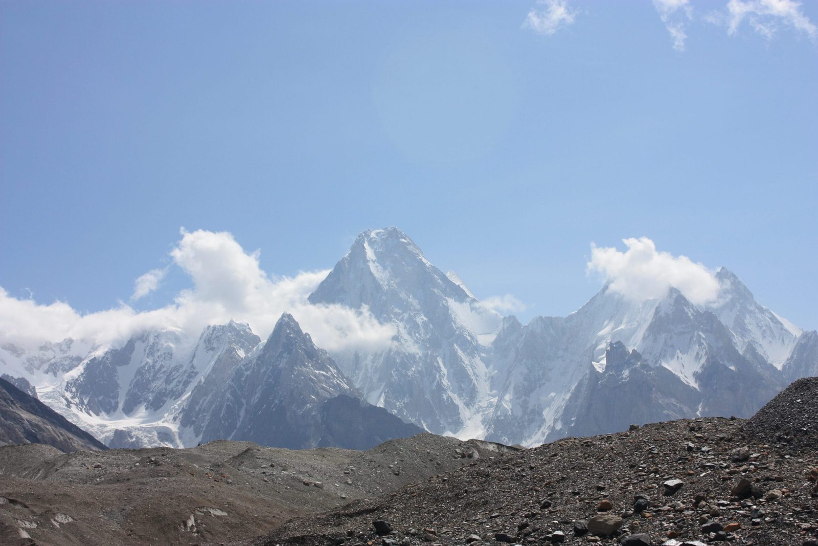
Gasherbrum V is a 7,147 m peak in the Gasherbrum group of the Baltoro Muztagh, Gilgit-Baltistan. It stands on the south ridge of Gasherbrum IV, above the head of the Baltoro Glacier. It was one of the last significant unclimbed summits in this corner of the Karakoram. That changed on 25 July 2014. The South Koreans Chi-young Ahn and Nak-jong Seong reached the top alpine style, by a new line on the South Face. Access is the classic Skardu to Askole jeep road followed by a seven-to-nine-day trek up the Baltoro to Concordia and the South Gasherbrum Glacier. The climbing season is short — roughly June to August — and this is a serious, technical, avalanche-exposed objective, not a first Karakoram peak.
We run our expeditions out of Skardu with our own Balti team, and we will be straight with you about this one: Gasherbrum V has been climbed once. There is no fixed-rope highway, no queue, no trade route. What we can do properly is the part that decides whether a team on this face gets home — the approach, the base camp, the porters, the food, the sat phone and the evacuation plan. The climbing above the bergschrund is yours.
Key Takeaways
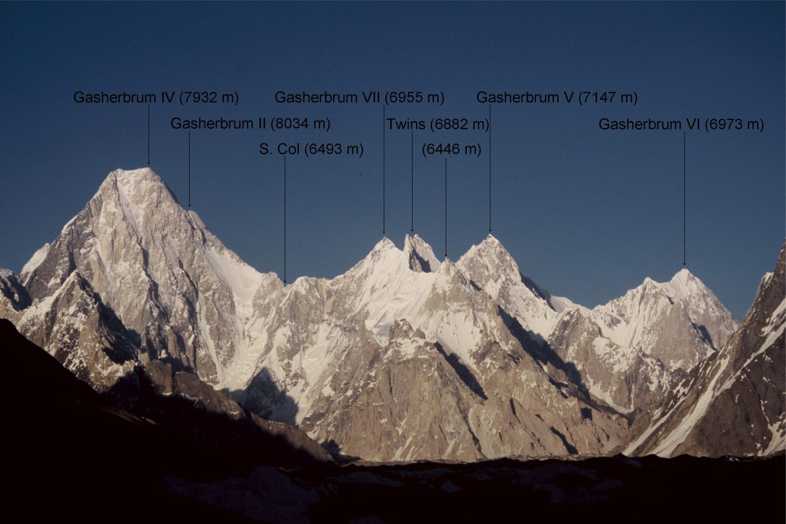
- Height: 7,147 m on the most accurate modern mapping. Older literature gives around 7,320 m; the Russian 1:100,000 topographic sheet shows 7,120 m. Treat the figure as approximate.
- Prominence: 654 m — the connecting col to Gasherbrum IV lies at 6,493 m, which is why it counts as an independent mountain rather than a shoulder.
- First ascent: 25 July 2014, Chi-young Ahn and Nak-jong Seong (South Korea), alpine style, new route on the South Face.
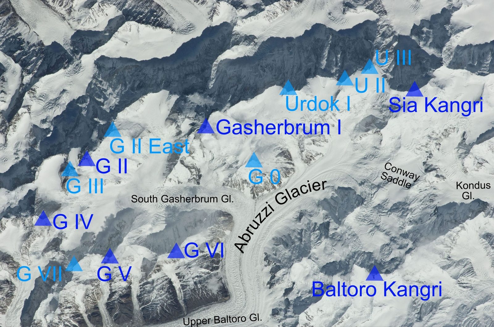
- Where: Baltoro Muztagh, at the head of the Baltoro Glacier, on the south ridge of Gasherbrum IV.
- Approach: Skardu to Askole by 4×4, then roughly 7–9 days trekking via Paiju, Urdukas, Goro II and Concordia to base camp on the South Gasherbrum Glacier.
- Season: June to August for climbing; the Baltoro approach is walkable roughly late April to early October.
Where Gasherbrum V is, and why it took so long to climb
First, the Gasherbrum group sits at the north-eastern end of the Baltoro Glacier, and it carries three eight-thousanders if you count Broad Peak. Everything else in the group has lived in their shadow. Gasherbrum V is the clearest example.
The name itself is worth getting right, because most brochures get it wrong. Gasherbrum is usually translated as “Shining Wall”, a reference to the west face of Gasherbrum IV. In Balti — the language spoken in our valleys — it actually comes from rgasha, beautiful, and brum, mountain. Beautiful mountain. That is the local reading, and it is the one we use.
Gasherbrum I to IV were named and numbered in the nineteenth century. Gasherbrum V and its neighbour Gasherbrum VI were not: for decades they were catalogued only as “peaks on the south ridge of Gasherbrum IV”. It was the Swiss geologist and Himalayan scholar Günter Oskar Dyhrenfurth who argued in 1934 that this was an independent mountain and deserved its own name, and proposed “Gasherbrum V”. The name stuck. The mountain stayed unclimbed for another eighty years.
The Gasherbrums by height — where G V actually sits
Meanwhile, standing under the group from Concordia, the eye goes to the eight-thousanders and to Gasherbrum IV’s wall. Gasherbrum V is the smallest of the named Gasherbrums in this chart, and that is precisely why nobody went there for eighty years: there was always a bigger prize a few kilometres away.
Schematic and approximate — drawn to illustrate the shape of the route, not for navigation.
Getting there: the Baltoro approach, step by step
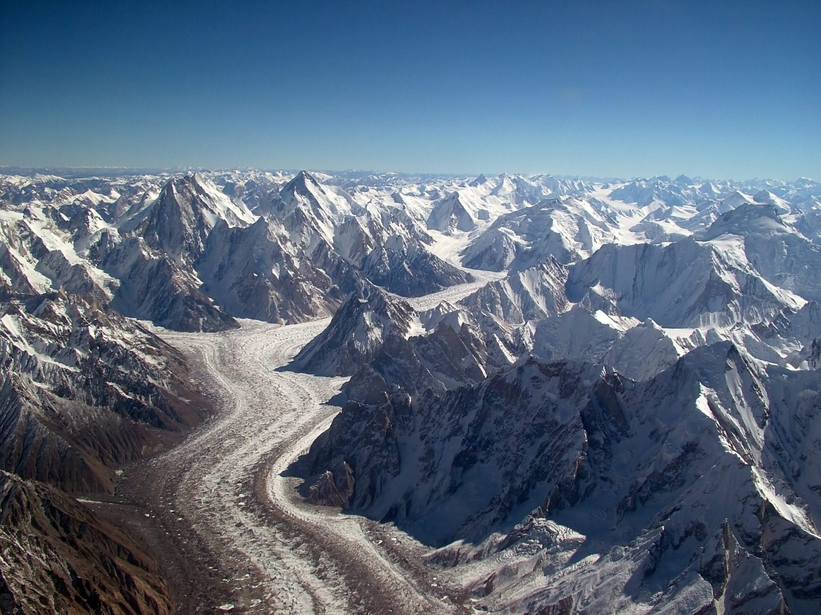
In short, there is no shortcut to the Gasherbrum basin. Everyone — K2 teams, Broad Peak teams, Gasherbrum I and II teams and anyone going to G V — walks the same glacier. Here is how a Gasherbrum V expedition is built on our side:
- Islamabad to Skardu. Fly if the weather allows, drive the Karakoram Highway if it does not. Both options and the buffer days they need are set out in our guide to reaching Skardu.
- Skardu to Askole. Roughly seven to nine hours by 4×4 up the Shigar and Braldu valleys. The road ends at Askole; from there it is feet and porters.
- Askole to Paiju. Two days along the Braldu to the last trees on the route. Paiju is where the porters rest before the ice.
- Paiju to Urdukas. Onto the Baltoro Glacier itself, past Liligo, with the Trango group and Paiju Peak overhead. Urdukas is a grass ledge above the moraine — the last real camp of its kind.
- Urdukas to Goro II. A long day on rubble and ice. Views open onto Gasherbrum IV ahead.
- Goro II to Concordia. The junction of the Baltoro and Godwin-Austen glaciers, around 4,600 m, with K2 to the north and the Gasherbrums closing the eastern horizon.
- Concordia to Gasherbrum Base Camp. East and then south-east onto the South Gasherbrum Glacier. Base camp for the Gasherbrums sits at roughly 5,000–5,150 m; the 2014 Korean team placed their Gasherbrum V camp lower, at about 4,770 m near the head of the Baltoro.
Acclimatising on the walk in
Therefore budget seven to nine trekking days from Askole to base camp, and do not compress it. That approach is your acclimatisation programme — see our acclimatisation guide before you plan the schedule.
Schematic and approximate — drawn to illustrate the shape of the route, not for navigation.
The 2014 first ascent: four days, three bivouacs, one push
Specifically, the Korean expedition led by Chi-young Ahn arrived in the summer of 2014 with four members: Ahn, Nak-jong Seong, Hyeong-woo Choi and Ji-eun Ahn. First they tried the north-east face and were stopped at about 6,400 m by bad weather, technical difficulty and avalanche danger. With only a few days left and without having recovered properly, Ahn and Seong switched to the South Face and went for it in a single push, with no camps stocked above base camp.
Then they left base camp at 4,770 m at 05:00 on 23 July, crossed roughly 3.5 km of broken glacier, and reached the bergschrund at about 5,700 m by mid-morning. They bivouacked at 6,560 m in a slanting crevasse. A day was lost to avalanche exposure and fatigue. On 25 July they set off at 03:00 and reached the summit at 19:20 — late, descending in the dark, losing the line and finding it again by following their own footprints back to the tent. They were at base camp by the evening of 26 July.
Afterwards Ahn described the face as around 70 degrees, ice under a nasty snow crust, with constant rockfall and avalanche. From bergschrund to summit is roughly 1,450 m of that. Read the account and you understand why nobody has queued up behind them. If you want a sense of how the whole Baltoro season works around weather windows like the one they used, our Baltoro climbing season guide lays it out.
When to go
| Months | Conditions | Verdict |
|---|---|---|
| April – May | Baltoro approach opening up; deep snow high on the glacier, cold nights, unsettled weather | Approach and reconnaissance only |
| June | Base camps established; snowpack still consolidating; useful acclimatisation window | Good for build-up, early for a summit push |
| July | Warmest, longest windows — the month of the 2014 first ascent | Best for climbing |
| August | Windows still possible; more melt-out, more rockfall on steep ground | Workable, watch the face conditions |
| September – early October | Clear, cold, golden light on the Baltoro; short days | Trekking and photography, not this face |
How hard is it, honestly
Hard. Not “challenging” in the brochure sense — genuinely hard, and with a single ascent on record there is no accumulated route knowledge to lean on.
- Altitude. 7,147 m, reached from a base camp around 4,770–5,150 m. That is a big vertical gain with no established high camps, which is why the 2014 pair went alpine style. You need to arrive already acclimatised from the approach.
- Terrain. Mixed ground on a face reported at around 70 degrees, ice under wind crust, with poor protection. This is technical alpinism at altitude, not a snow plod.
- Objective hazard. Rockfall and avalanche were the defining features of the first ascent, and the South Gasherbrum Glacier itself carries serac and crevasse risk on the way in.
- Fitness and experience. You should already have 7,000 m experience and technical alpine climbing at that altitude. If Gasherbrum V is your first Karakoram objective, it is the wrong objective — look at Spantik or the K2 Base Camp trek first.
Safety: the real risk, said out loud
Above all, the named killers here are avalanche and rockfall on the face, and crevasse fall on the South Gasherbrum Glacier — the same basin where serac debris off Gasherbrum I and Gasherbrum V threatens the route between base camp and Camp 1 on the eight-thousanders. Nothing about this is theoretical. Every Karakoram Venture expedition carries a satellite phone at base camp, established helicopter-rescue contacts for the Baltoro region, and a written evacuation plan agreed before you leave Skardu, plus a check that your insurance actually covers high-altitude rescue in Pakistan. Budget operators cut exactly these things, and you do not find out until the day you need them. Our insurance guide covers what your policy has to say.
Permits and access
Trekking in the open zones of Gilgit-Baltistan does not need a trekking permit — but Gasherbrum V does not fall under that. Any peak above 6,500 m requires a mountaineering permit, applied for through a Pakistani operator registered with the Directorate of Tourist Services, and expeditions are assigned a liaison officer. Allow real lead time; permit processing runs in weeks, not days. Separately, you need the correct visa — a mountaineering or trekking visa, not a plain tourist visa. Our Pakistan visa guide for trekkers walks through it. Fees and conditions are revised periodically, so confirm the current position with us before you commit dates.
Getting there, and what it costs
Of course, every Gasherbrum V expedition is a private, built-to-order trip — there is no fixed departure for a peak with one ascent. The cost depends on team size, how many days you want at base camp, porter loads, the permit and liaison officer, and whether you also want a support team on the glacier.
We keep pricing personal rather than posting a number that goes stale. Tell us your team, your dates and your plan for the face, and we will build the logistics and quote them line by line: jeeps, porters, cook staff, base camp equipment, permit handling, communications, evacuation cover. Fair price, no corners cut — and you will see what each part costs rather than a single lump sum.
If you are weighing Gasherbrum V against something else on the same glacier, our guides to Gasherbrum III and Baltoro Kangri are useful comparisons.
Frequently asked questions
How high is Gasherbrum V?
7,147 m on the most accurate available mapping, with a topographic prominence of 654 m. However, older literature gives figures around 7,320 m and the Russian 1:100,000 military sheet shows 7,120 m, so the height should be treated as approximate. The col linking it to Gasherbrum IV sits at 6,493 m.
Has Gasherbrum V been climbed?
Yes, once. Chi-young Ahn and Nak-jong Seong of South Korea made the first ascent on 25 July 2014 by a new route on the South Face, climbed alpine style in a single push over four days with three bivouacs. An earlier attempt by the same expedition on the north-east face was turned back at around 6,400 m.
How do you get to Gasherbrum V base camp?
Fly or drive Islamabad to Skardu, take a 4×4 for seven to nine hours to Askole, then trek roughly seven to nine days up the Baltoro Glacier via Paiju, Urdukas, Goro II and Concordia to the South Gasherbrum Glacier. Indeed, it is the same approach used by K2, Broad Peak and Gasherbrum I and II expeditions.
Do I need a permit to climb Gasherbrum V?
Yes. Peaks above 6,500 m in Gilgit-Baltistan require a mountaineering permit, applied for through a registered Pakistani tour operator, and expeditions are assigned a liaison officer. You also need the correct visa category for mountaineering rather than a standard tourist visa. Fees and rules change, so confirm the current requirements before booking flights.
Is Gasherbrum V a good first Karakoram peak?
No. With one ascent on record, a face reported at around 70 degrees and serious avalanche and rockfall exposure, it is an objective for climbers who already have technical alpine experience above 7,000 m. Instead, for a first Karakoram climb, Spantik is a far better choice; for a first visit to this glacier, walk to Concordia and K2 Base Camp instead.
Plan it with the team that lives here
Karakoram Venture is based in Skardu. Our guides, cooks and high-altitude porters are Balti, from the valleys below these peaks — we are not a broker who hands you to somebody else once you land. Sat phone at base camp, a real evacuation plan, fair price, no corners cut.
WhatsApp: +92 312 9921574 · Email: info@karakoramventure.com
Send us “Gasherbrum V” with your dates and team size and we will come back with a logistics plan and a line-by-line quote.
Sources & attribution: elevation, prominence, naming history and first-ascent details from Wikipedia (Gasherbrum V), the American Alpine Journal (Chi-young Ahn, “Korean Direct: The First Ascent of Gasherbrum V”, AAJ 2015) and PlanetMountain’s report of the 2014 expedition; permit and access information from Pakistani operator and Gilgit-Baltistan tourism sources. Heights are approximate and sources differ. Images: Black Zero (CC BY 2.0), Florian Ederer (public domain), Guilhem Vellut (CC BY-SA 2.0), NASA / Rupert Pupkin (public domain), all via Wikimedia Commons.

