



The Chogo Lungma Glacier is a roughly 40 km river of ice running out of the Basha Valley in Shigar District, Baltistan, and the trek along it starts at Arandu village (about 2,770 m), the last houses on the road. Most people walk three to four days up the glacier to Spantik Base Camp at about 4,300 m and the same back, which makes a Skardu-to-Skardu trip of around twelve days. The season is June to September, with July and August the most reliable. It is not technical, but it is real glacier ground: moraine, meltwater and crevasses. Call it moderate-to-hard, not beginner.
We run this out of Skardu with our own Balti team, and we’ll be straight with you: the Chogo Lungma is not the Baltoro. There is no queue of expedition trains, no Concordia amphitheatre, no line of trekkers filming each other at K2 Base Camp. What there is instead is a huge, working glacier with almost nobody on it, three seven-thousanders standing over it, and villages in the Basha Valley that see a fraction of the traffic Askole does. That is the trade, and it is a good one.
Key takeaways
- Length: the Chogo Lungma is commonly given as about 44 km, though some sources say closer to 38 km. Treat roughly 40 km as the working figure.
- Trailhead: Arandu (about 2,770 m), the last village in the Basha Valley, 5–7 hours by 4×4 jeep from Skardu via Shigar.
- High point: Spantik Base Camp at about 4,300 m, low by Karakoram standards, which is exactly why it suits first-time glacier trekkers.
- The giants: Malubiting (7,458 m), Haramosh (7,409 m) and Spantik / Golden Peak (7,027 m) all stand over this basin.
- History: reached by Godfrey Vigne in 1835, the first of the great Karakoram glaciers to be seen by European exploration, and surveyed by Fanny Bullock Workman and William Hunter Workman from 1902.
- Season: June to September. July and August give the most dependable glacier conditions.
Where the Chogo Lungma is, and why it matters
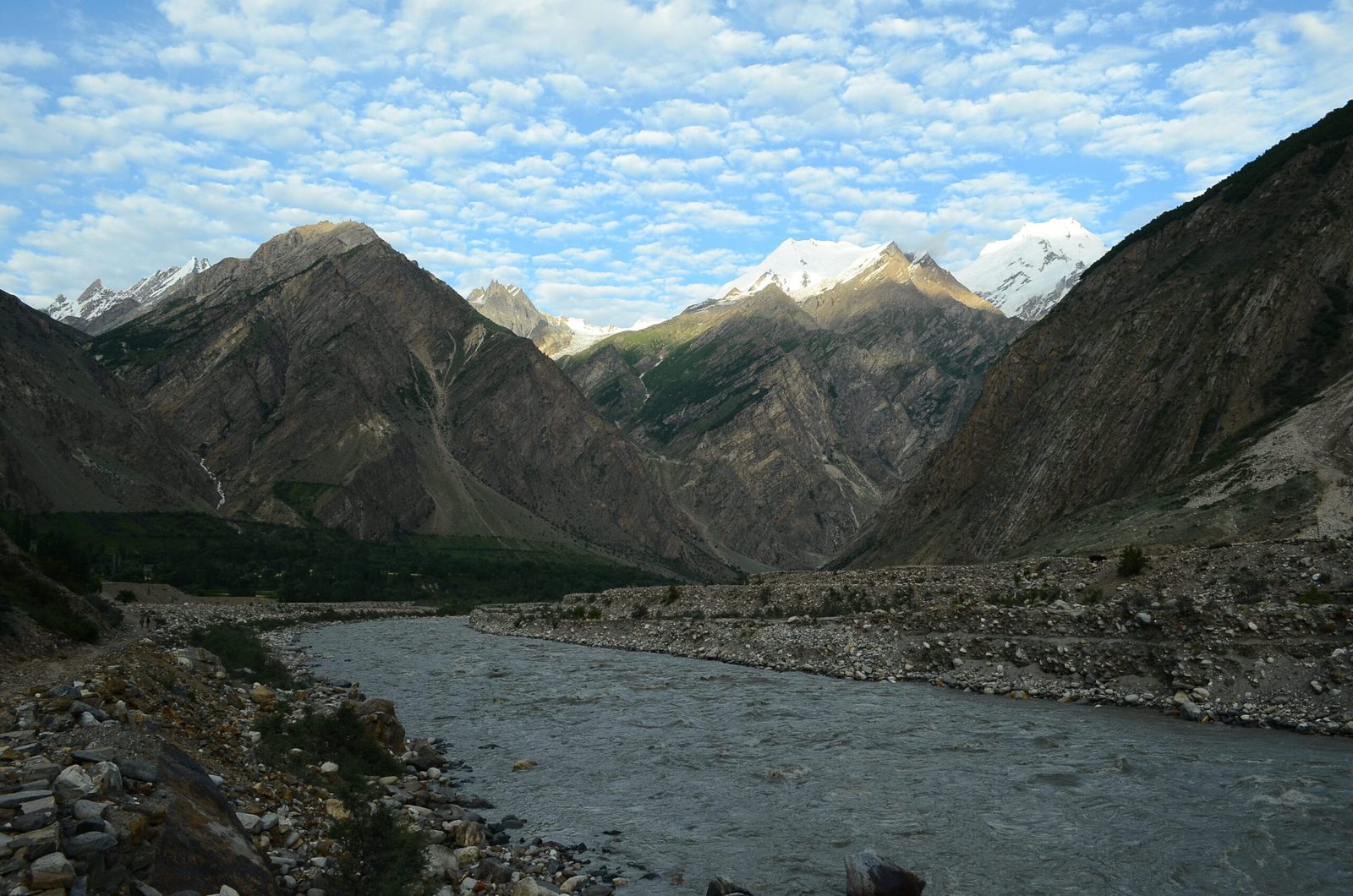
Above Shigar the valley splits. One branch is the Braldu, which carries every jeep bound for Askole, the Baltoro and K2. The other branch is the Basha, and almost nobody turns up it. Follow the Basha to its head and the road ends at Arandu, a village of apricot trees and stone-walled fields sitting more or less on the snout of the Chogo Lungma Glacier.
The name is Balti and it is not poetry: chogo lungma means big valley. That is what it is. The glacier drains a basin ringed by serious mountains and feeds the Basha River, which joins the Braldu at Shigar and then runs into the Indus below Skardu. Every field you pass on the drive up is watered by this ice.
It matters for three reasons. The glacier is the natural approach to Spantik, the Golden Peak, which is the most sensible first 7,000 m climb in Pakistan. It is the southern approach to Malubiting, one of the hardest 7,000ers in the range. And on its own, as a walk, it gives you the scale of the Karakoram without the altitude and the price of a Baltoro trip.
The route, step by step
This is the shape we run. Days can shift for weather, river crossings or how a group is acclimatising, so treat it as the plan, not a promise.
- Day 1. Arrive Skardu (about 2,230 m). Fly from Islamabad if the weather allows, or come overland. Kit check, permits, briefing.
- Day 2. Skardu to Arandu (2,770 m), 5–7 hours by jeep. Through Shigar, then up the Basha Valley past Bisil, Sesko and Thisar. Rough road, long day, good one.
- Day 3. Arandu. An easy acclimatisation walk above the village and a first look at the glacier snout.
- Day 4. Arandu to Chogo Brangsa (about 3,322 m). Onto the lateral moraine and up the true left of the glacier. Grassy camp.
- Day 5. Chogo Brangsa to Bolocho (about 3,800 m). Mixed moraine and ice. Longer and rougher than the day before.
- Day 6. Bolocho to Spantik Base Camp (about 4,300 m). Mostly on the glacier now, roped where it needs it.
- Day 7. Base camp day. Rest, or walk up towards the Spantik southeast ridge for the view down the basin.
- Days 8–10. Return to Arandu by the same camps, faster on the descent.
- Day 11. Arandu to Skardu by jeep.
- Day 12. Buffer day in Skardu. Keep it. Skardu flights get cancelled, and this is the day that saves your onward booking.
The giants over the ice
Four mountains define this basin, and they are worth knowing before you walk under them.
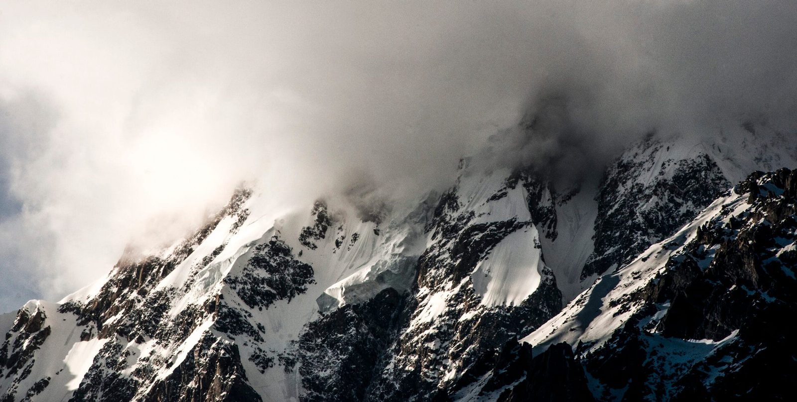
Malubiting (7,458 m) is the highest and the hardest. Six expeditions, German, British, Japanese, Polish and Pakistani, failed on it between 1955 and 1970. It was finally climbed on 23 August 1971 by four Austrians from the Styrian group of the Alpenverein: Hanns Schell, Hilmar Sturm, Kurt Pirker and Horst Schindlbacher.
Spantik, the Golden Peak (7,027 m), was first climbed in 1955 by a German expedition led by Karl Kramer, by the southeast ridge. That ridge is still the normal route, and it is why Spantik is the peak we recommend to people making their first attempt at 7,000 m.
Haramosh (7,409 m) sits about 65 km east of Gilgit in the Rakaposhi-Haramosh mountains and is better known from the Kutwal Lake side. Sosbun Brakk (6,413 m), on the Shigar flank, was climbed on 4 July 1982 by a Japanese team led by Seiichi Kawauchi.
The first glacier the outside world found
Here is the fact most people get wrong. The Baltoro is the famous one, but the Chogo Lungma was first. Godfrey Thomas Vigne (1801–1863), an English traveller and the first European known to have visited Baltistan, reached it in 1835, making it the first of the great Karakoram glaciers to be described by European exploration. He called its snout the grandest sight of his travels.
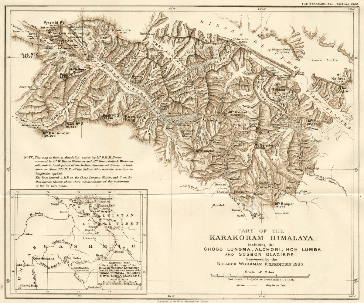
Nothing much followed for sixty-odd years. Then Fanny Bullock Workman and her husband William Hunter Workman arrived. They were the first Westerners to properly explore the Chogo Lungma, in 1902, and came back the following year. Fanny got within a few hundred metres of a summit above the glacier in long skirts and laced boots. Their survey map, drawn in 1903, is still the clearest picture of how the basin fits together.
Ganchen, the peak that stands over Bisil village on the drive in, was first climbed in 1978 by a Japanese team under Tohru Shibazaki, who camped on the Ganchen–Hikmul col at 5,930 m. You will see it long before you see the glacier.
When to go
| Months | Conditions | Verdict |
|---|---|---|
| April – May | Basha Valley green and in blossom, but heavy snow still on the upper glacier and rivers rising. | Valley yes, glacier no. |
| June | Glacier opening up. Meltwater channels running hard by afternoon. Fewer people than July. | Good, with a flexible plan. |
| July – August | The most settled and reliable window. Warm days, firm walking, all camps usable. | Best. Book early. |
| September | Cooling fast, clearer air, autumn colour low down. Cold nights at base camp. | Excellent for photography. |
| October – March | Snow closes the upper glacier and the jeep road becomes unreliable. | Not a trekking season. |
If you are still choosing a month for the region generally, our guide to the best time to visit Gilgit-Baltistan covers the wider picture.
How hard is it, honestly
Moderate to hard. Not technical, not beginner.
Altitude. The high point of about 4,300 m is modest, well under K2 Base Camp, and the gain is gradual. This is the trek’s biggest advantage: altitude sickness is less likely here than on the Baltoro. Read our acclimatisation guide before you come anyway.
Terrain. This is what actually makes it hard. Days on the Chogo Lungma are spent on loose lateral moraine, rubble-covered ice, and boulders that move under you. Ankles take a beating. There are crevasses on the upper glacier and we rope up where the ground needs it.
Fitness. If you can walk six to eight hours on rough ground, several days in a row, carrying a daypack, you are ready. If your longest recent walk is two hours on a path, you are not. Start training now.
Remoteness. Above Arandu there is no village, no road, no phone signal and no shop. That is the appeal, and it is also the reason the next section exists.
Safety and permits on the Chogo Lungma Glacier
The real risk here is remoteness, not altitude. Once you are past Arandu, a broken ankle on moraine or a crevasse fall is a multi-day problem, not an afternoon one. We carry a satellite phone on every trip, not as a slogan but as the only way to call for help from the Chogo Lungma. We work with established helicopter-rescue contacts for Gilgit-Baltistan, and we will not take a booking without confirming your insurance covers helicopter evacuation and trekking above 4,000 m. Budget operators cut the sat phone first because nobody checks it until the day it matters. Ask us to show you ours. Our insurance guide explains what cover you actually need.
Permits and visa. The Chogo Lungma trek to Spantik Base Camp is normally treated as an open-zone trek rather than a restricted-zone one, which keeps the paperwork light. If you intend to climb Spantik or Malubiting rather than walk to base camp, that is a different matter: a mountaineering permit and royalty through the relevant authorities, arranged well in advance. Every foreign visitor needs a Pakistan visa, and trekkers and climbers should apply on the trekking and mountaineering category rather than the plain tourist one. Rules change, so we confirm the current position for your specific itinerary before you book. See our Pakistan visa guide for trekkers.
Getting there, and what it costs
Islamabad to Skardu is a short flight when the weather cooperates and a long, spectacular drive when it does not. Build in buffer days either way. Our how to get to Skardu guide lays out both options. From Skardu it is 4×4 jeeps through Shigar and up the Basha Valley, five to seven hours to Arandu.
On price: we keep pricing personal rather than posting a number that goes stale the moment jeep hire or porter rates move. Tell us your dates, your group size and whether you want the base-camp trek or a full Spantik attempt, and we will send you a real cost against a real itinerary. What we will promise is the shape of it: a fair price, and no corners cut on guides, food, porter loads or the safety kit. Being local is what lets us do both.
Before you pack, run through our Karakoram trek packing list. Boots with real ankle support are not optional on this one.
Frequently asked questions
How long is the Chogo Lungma Glacier?
It is commonly given as about 44 km, though some sources put it closer to 38 km. Around 40 km is a safe working figure. It runs out of the head of the Basha Valley in Shigar District, Gilgit-Baltistan.
Do I need mountaineering experience for the Arandu trek?
No. Walking to Spantik Base Camp is a trek, not a climb. No ropework skill is required of you, though your guides will rope the party on the upper glacier where crevasses demand it. You do need good general fitness and to be comfortable on rough, loose ground for several days.
How does this compare to the K2 Base Camp trek?
Shorter, lower, cheaper and far quieter. K2 Base Camp reaches about 5,150 m and puts you under the second-highest mountain on earth. The Chogo Lungma tops out around 4,300 m and you may not meet another group. Choose the Baltoro for the famous mountains and Chogo Lungma for solitude and a gentler altitude profile.
What is the best month to trek the Chogo Lungma?
July and August are the most reliable, with settled weather and every camp usable. June works with a flexible plan, and September is excellent if you want clear air and autumn colour and can handle cold nights at base camp.
Is there phone signal or resupply above Arandu?
None. Arandu is the last village, the last road and the last signal. Everything above it is carried in, which is why we plan around a satellite phone and a confirmed evacuation route rather than assuming we can call for help.
Plan your Chogo Lungma trek with the people who live here. We are a local Balti team based in Skardu, not a broker who sells your booking on to someone else. Your guides grew up in these valleys, your porters come from the villages you walk through, and the person who answers your message is the person who runs the trip.
WhatsApp us on +92 312 9921574 or email info@karakoramventure.com. Tell us your dates and group size and we will come back with a real itinerary and a real price. Local hands, real safety, fair price.
Sources & attribution: elevations and first-ascent details cross-checked against Wikipedia, the Himalayan Journal and American Alpine Club records. Glacier length is given variously as 38–44 km and is treated as approximate; camp altitudes are approximate and vary by season and operator. Images: Basha Valley by Muhammad Hussain Abbass (CC BY-SA 4.0); Ganchen above Bisil by Zafaryaab (CC BY-SA 4.0); Malubiting by Anees Javaid (CC BY-SA 3.0); 1903 Chogo Lungma survey map by Fanny Bullock Workman and William Hunter Workman (public domain), all via Wikimedia Commons.

